New first-of-its-kind map reveals ‘whale superhighways’ throughout the oceans
"Together, we can protect blue corridors for whales, our ocean, and ourselves."
A new WWF report plots the major migration paths used by whales around the world, highlighting the increasing threats these important species face.
Each year, whales travel hundreds to thousands of kilometres as they migrate to follow food sources, seek out mates, and raise their young. During these migrations, they face a number of threats due to human activities. Many become tangled in fishing gear. Others are struck by ships that travel the same waters. They are also affected by pollution, shrinking habitats, and the growing impacts of climate change.
According to a new report from the World Wildlife Fund — titled Protecting Blue Corridors: Challenges and solutions for migratory whales navigating national and international seas — these threats "are creating a hazardous and sometimes fatal obstacle course for the marine species."
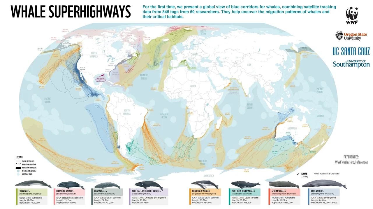
Included in the report is a new map — the first of its kind — which was compiled using satellite tracking of tagged whales. It reveals the numerous pathways through the oceans that different whale species follow regularly. Researchers call these pathways "blue corridors" or "whale superhighways."

This map, from the new Protecting Blue Corridors report, plots the 'superhighways' used by eight different whale species around the world. Credit: WWF
Dr. Aurelie Cosandey-Godin, a senior specialist in Marine Ecosystems and Sustainable Shipping with WWF-Canada, is one of the co-authors of Protecting Blue Corridors. In an email to The Weather Network, she provided her insights on the report.
The Weather Network: What are "Whale Superhighways" and how did scientists gather the data to plot them?
Dr. Aurelie Cosandey-Godin: 'Whale Superhighways' are migration routes essential for whales' survival. They are the paths they follow when moving between critical ocean habitats – the places where they feed, mate, give birth, nurse young, and socialize. For the first time, Protecting Blue Corridors maps 845 satellite tracks of migratory whales worldwide, highlighting 30 years of scientific data contributed by more than 50 research groups.
Where do these superhighways run through Canadian waters, and which whale species travel along them?
On all coasts of Canada, our waters are essential to the survival of many of the great whales. They can migrate for thousands of kilometres each year along Canada's coasts, in and out of international and national waters. Our report shows the migration corridors of blue, fin, humpback and gray whales off of North America's west coast. For the gray whale, satellite tagging documented their yearly round-trip migration between the Arctic and Mexico along the west coasts of Canada and the United States. On the east coast of Canada, North Atlantic right whales migrate seasonally along Canadian and U.S. coasts. In winter months, the species is found in their calving grounds off South Carolina, Georgia, and northeastern Florida. Then in the spring they start slowly moving north to their feeding and mating grounds in the Gulf of Maine and eastern Canadian Atlantic.
What are the greatest risks to whales along these migration paths? What about those paths specifically in Canadian waters?
Entanglement in fishing gear (also called bycatch), ship strikes, chemical and noise pollution, loss of habitat and climate change are impacting whales, their prey, and habitats all around the globe and making their migration increasingly dangerous. For example, an estimated 300,000 cetaceans are killed each year as a result of fisheries bycatch. Ever-expanding shipping traffic is leading to more collisions between whales and ships, and is more than doubling underwater noise pollution each decade. Climate change is shifting their prey populations — especially in the polar regions — making it harder for them to find food.
All of these risks threaten whales in Canadian waters. In recent years warming waters have affected prey availability with direct impacts on some of the great whales migrating into Canadian waters. On the West coast of North America from Mexico through Alaska, gray whales have been stranded on beaches because severe malnutrition — related to lack of food caused by climate change — has driven them to look for food in dangerous shallow waters. On the East Coast, warming waters associated with climate change have caused North Atlantic right whales' migration to shift northward into the Gulf of St Lawrence, which puts the population at a greater risk of ship strikes and fishing gear entanglements.
What can we do to reduce these risks? Now that we know where these superhighways are, is it as simple as avoiding them? Is avoiding them even possible, given where our shipping lanes are, and where our industrial fishing takes place?
It's pretty clear that in many cases migration corridors are perilous. We are calling for the protection of six global blue corridors by 2030. This is a new conservation approach to safeguard whales, through enhanced cooperation from local to regional to international levels. This includes a range of responses including establishing networks of marine protected areas overlapping international and national waters as well as implementing holistic management approaches. This would include achieving 'zero bycatch' in fisheries, eliminating and cleaning up 'ghost gear', which is abandoned, lost, or otherwise discarded fishing gear, and moving ships away from critical whale habitats where possible and setting speed limits where avoidance is not possible.
In your opinion, what is the most important thing Canadians should know about from this new report?
Six out of the 13 great whale species are classified as Endangered or Vulnerable, even after decades of protection. Some of our great whales could go extinct within our lifetimes — unless we act now. Together, we can protect blue corridors for whales, our ocean, and ourselves.
Thumbnail image courtesy WWF


