Six ways the weather can scar, shift, and snap the Earth itself

Rivers shift, hills collapse, and tornadoes can leave behind scars that are visible for years after a devastating storm
Extreme weather can reshape our world in the blink of an eye. Ferocious storms are capable of changing communities for generations, leaving behind everlasting reminders of their raw power.
There’s no shortage of ways that the weather can alter the very ground beneath our feet. Here are six events that can scar, shift, and crumble the Earth itself.
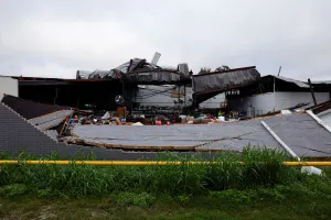
Tornadoes leave behind deep scars
Tornadoes can devastate entire communities in a matter of seconds, ripping apart homes, uprooting trees, and flattening crops along their paths.
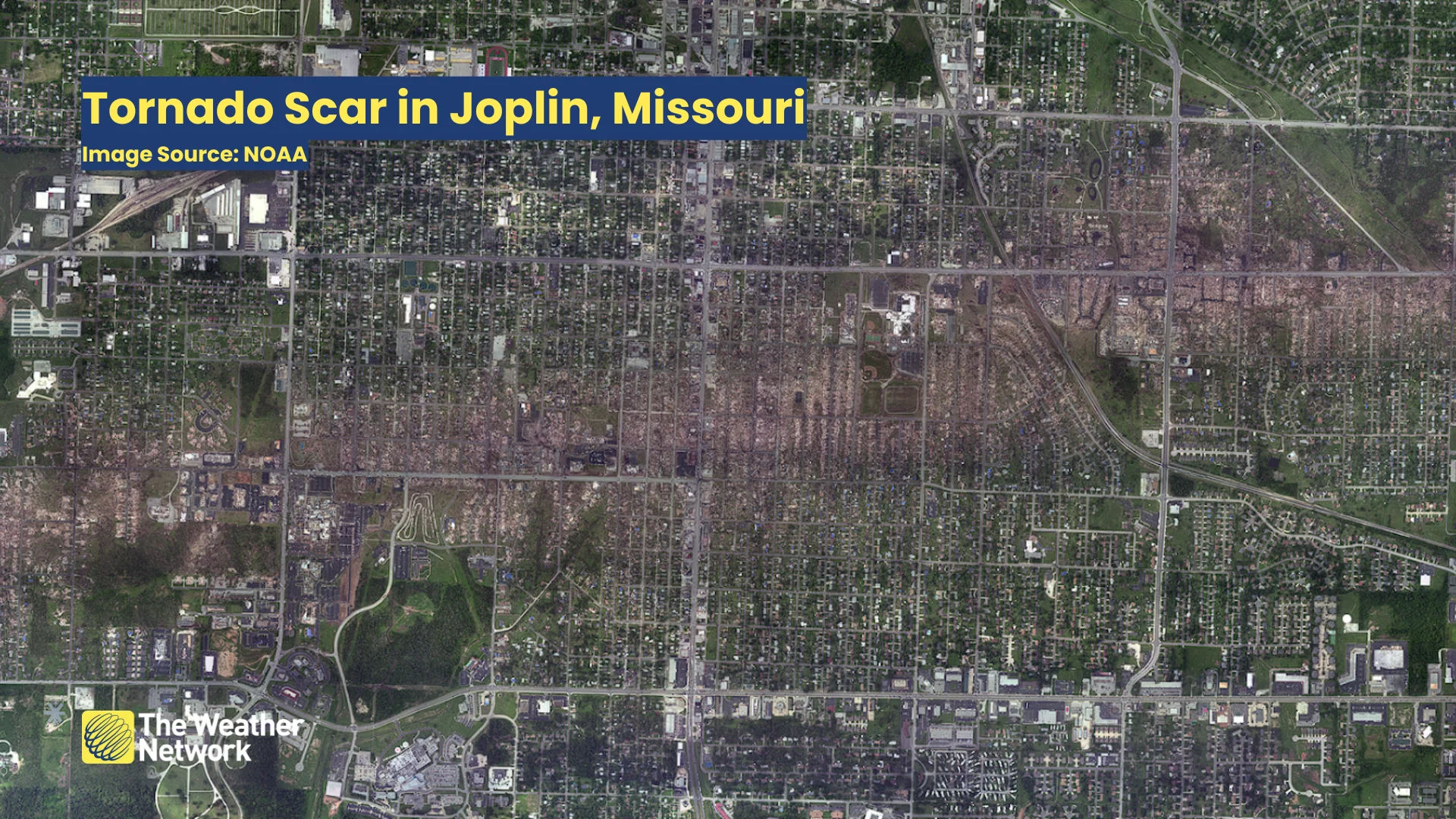
Downed trees and scoured fields turn brown in the days and weeks after the storm, leaving behind a scar that’s visible long after damaged buildings are cleaned up and repaired. A tornado scar can last for years or even decades after particularly strong tornadoes.
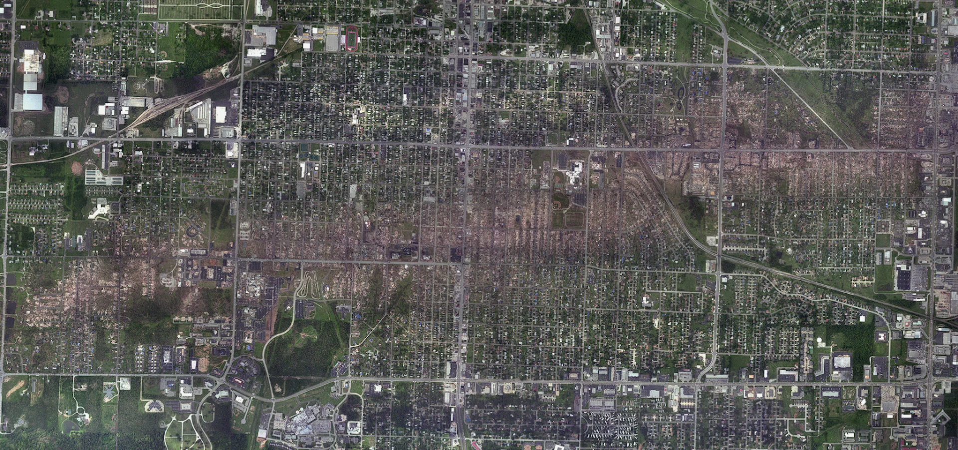
The above satellite image shows the immediate aftermath of the EF-5 tornado that ripped through Joplin, Missouri, back in May 2011. It’s still possible to clearly see the tornado’s path through the city on satellite imagery even more than a decade later.
Floods constantly reshape rivers
It’s mesmerizing to fly over a river and see a ribbon of glistening water twist and turn for as far as the eye can see. Each bend in a river is a testament to the raw power of water.
Riverbends form as the relentless force of water erodes certain parts of the riverbank while depositing sediments in areas of slower water movement. Over the years, this process creates dramatic meanders in a river as it flows across the landscape.
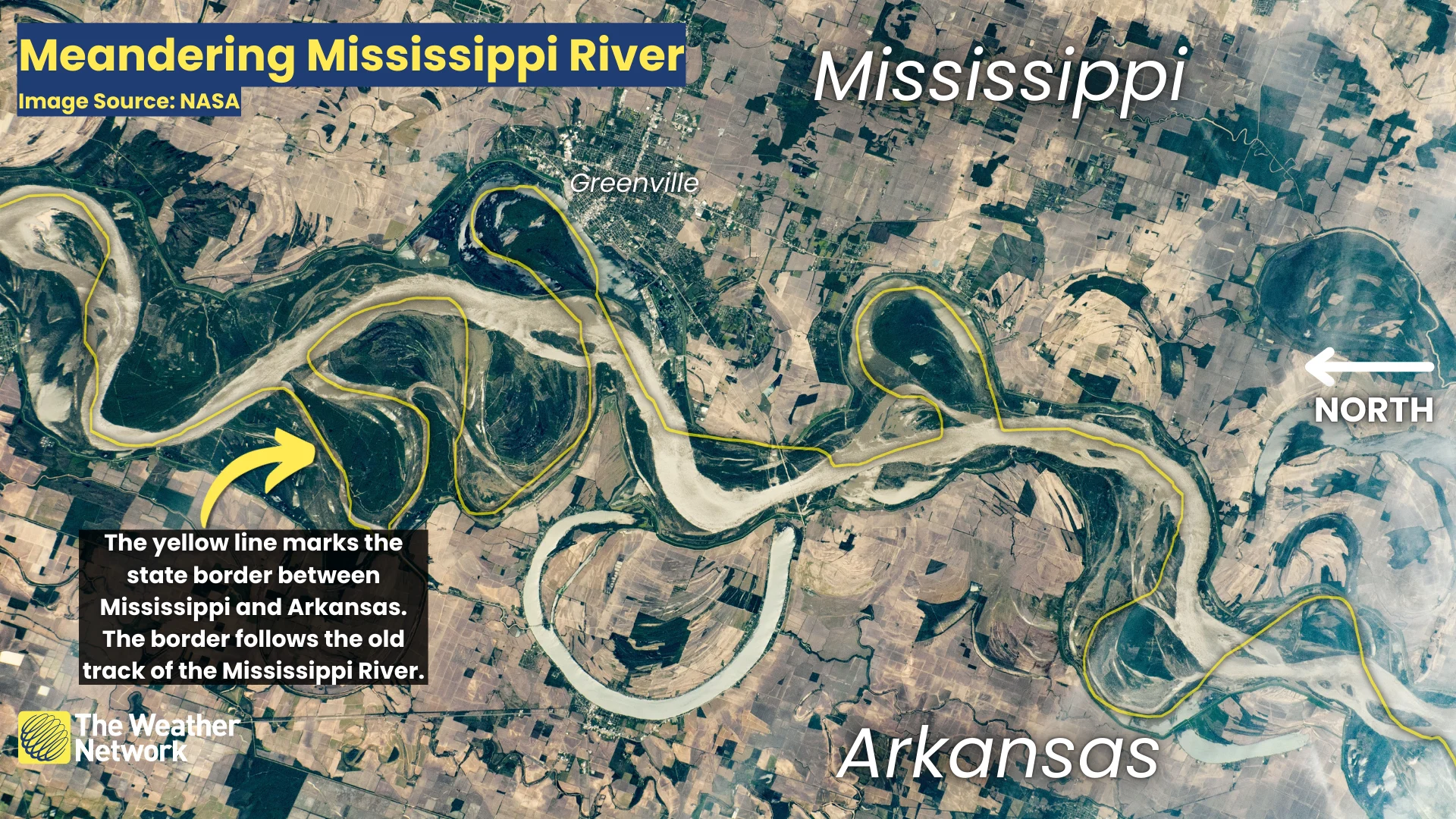
Floods can dramatically sever a meander off from the main flow of the river, leaving behind a stagnant pool of water known as an oxbow lake. This is an endless process that constantly recarves the river itself.
The image above shows the Mississippi River along the border between the states of Mississippi and Arkansas. Officials drew the state borders based on the old track of the river. Over the years, floods changed the shape of the river so much that it no longer resembles the river as it appeared more than a century ago.
WATCH: Satellite images reveal tornado scars
Hurricanes can reshape the coastline
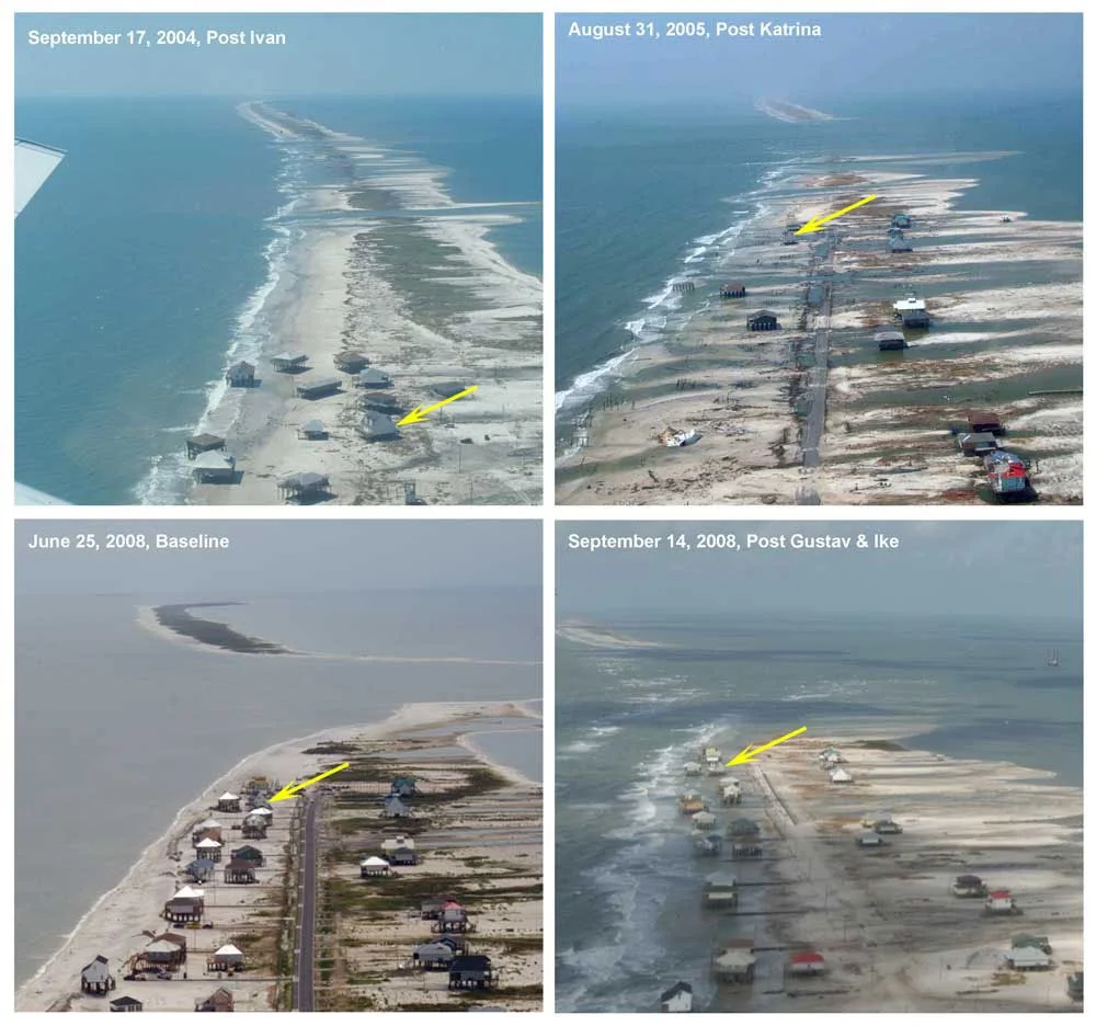
Hurricanes can scar communities as much as a tornado—but they can also reshape the land itself. Coastlines around the world are routinely altered by significant hurricane landfalls.
Relentless winds, mammoth waves, and destructive storm surge flooding can erode coastlines and change the outline of islands in their wake. Hurricane Fiona in 2022 led to major coastal erosion in Prince Edward Island, for instance.
(Image courtesy: USGS)
The image above shows one extreme example of hurricanes altering the shape of the coastline. Dauphin Island, Alabama, is particularly vulnerable to landfalling storms.
The United States Geological Survey (USGS) surveyed the same stretch of Dauphin Island after Hurricanes Ivan, Katrina, Gustav, and Ike, showing how each storm gradually eroded the land and changed the very shape of the island.
Sinkholes can swallow the ground in a flash
Rainy weather can leave behind more than mud and soggy grass.
Runoff seeping deep into the ground can erode softer types of bedrock, leading to large cavities developing underground. Sometimes, these large pockets of eroded rock weaken and collapse in on themselves, forcing the ground above to suddenly give way as a sinkhole.
Sinkholes are surprisingly common around the world, though the odds you’ll ever encounter one are fairly slim. Security cameras captured a particularly dramatic sinkhole swallowing a soccer field in the United States in June 2024. While that particular collapse wasn’t weather-related, it demonstrates the violent nature of a sinkhole’s formation.
Cryoseisms can jolt you awake on a cold night
Another issue arises during the winter months when groundwater seeps into the rocks below. Loud booms are possible on frigid nights when water in the bedrock freezes and expands. This pressure can crack the bedrock, leading to an event known as a cryoseism.
Cryoseisms, sometimes called frost quakes, can be frightening if you don’t know the source of the loud booming sound, which is sometimes accompanied by an earthquake-like jolt felt by nearby homes. They rarely if ever cause any damage—just some frayed nerves.
Landslides can wipe away hills in seconds
Heavy rain isn’t just a flood risk. Loose soils in hilly areas can easily give way after an extended period of wet weather, unleashing large and sometimes destructive landslides into the valleys below.
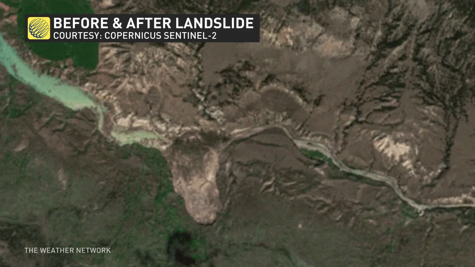
Landslides are a frequent hazard in the tropics during hurricane season, posing a significant threat to communities on the mountainous islands of the Caribbean and throughout Central America.
However, we do see impactful landslides here in Canada from time to time. A major landslide occurred on British Columbia’s Chilcotin River in late July 2024, damming up the river and leading to a significant flood threat to communities near and downstream of the landslide.