Scud clouds are scary tornado lookalikes – how to tell them apart

Dark skies ahead of an ominous storm can blur the line between harmless and hazardous. Here’s how to tell if that spooky cloud is really a budding twister
Staring at the clouds during a tornado warning is a nerve-racking experience. Thunderstorms fill our skies with a tremendous variety of colours and textures as they lumber across the horizon.
The clouds hanging beneath an approaching thunderstorm can swoop and swirl as they race around on gusty winds, sometimes poking toward the ground as if they were funnel clouds or full-blown tornadoes.
But not all scary, suspicious clouds looming beneath a storm are an indication that a tornado is imminent.
DON'T MISS: Don’t fall victim to these seven dangerous tornado myths
Scud clouds are common on a stormy day
A boiling summertime sky can feature more than a dozen types of clouds floating at all levels of the atmosphere, from just above the treetops to higher than the cruising altitude of passenger jets.

A scud cloud beneath a severe thunderstorm in Acme, Alberta, in 2019. (Image submitted by Jeff Adams.)
Some of the most impressive clouds are the result of a thunderstorm’s outflow, or the cold burst of wind that blows out of the base of a storm. This outflow acts like a miniature cold front, scooping up muggy air and forcing it to rise.
It’s common to see dark, fractured cloud formations beneath an approaching storm as this chilly outflow collides with the unstable air ahead of it. These ominous shreds of clouds lurking beneath the base of a storm are known as fractus clouds, more commonly called scud clouds.
WATCH: Don’t fall victim to these dangerous tornado myths
Scud clouds are speedy but harmless
A scud cloud is harmless on its own. While they can look positively spooky, they’re just the result of moist air getting scooped skyward by a healthy thunderstorm churning up the atmosphere around it.
Part of their frightening appearance is the fact that they usually move much faster than the storm itself as a result of gusty winds near the ground.
Sometimes, scud clouds can even appear to stream straight into the bottom of a storm, almost like a waterfall of clouds in reverse. These rising scud clouds are getting pulled into the thunderstorm’s updraft, part of the flow of unstable air that feeds a thriving storm its energy.
There are other lookalikes, as well
Ominous appendages hanging off of clouds aren’t always detached from the thunderstorm itself.

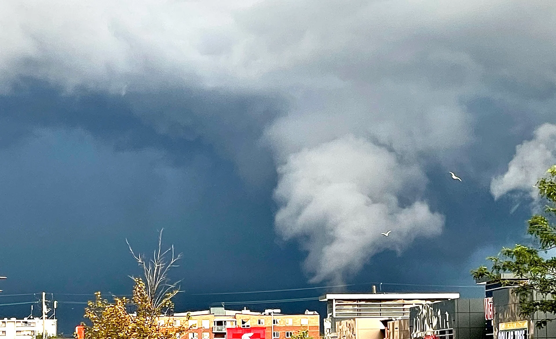
A spooky but non-tornadic cloud over Reidsville, North Carolina, in May 2024. (Dennis Mersereau)
The above image was taken during an everyday thunderstorm on a warm spring afternoon. The looming cone-shaped cloud was rapidly rising into the sky, appearing at first glance to be an ominous tornado just over the trees.
Thankfully, it was just the thunderstorm’s updraft moving over a cold lake. Air just over the lake’s surface was much cooler than the surrounding air. Moisture condensed as it rapidly rose toward the base of the thunderstorm, giving the illusion of a tornado without any danger to those nearby.
What to look for if you suspect a tornado
Given their jagged appearance and startling movements, it’s easy to mistake a scud cloud for a funnel cloud or tornado looming beneath an approaching storm.
What’s the big difference? Rotation.
Scud clouds don’t rotate. They can feature some funky movements and possibly even twirl around a little bit for sure, but they don’t rotate. The spinning motion within a developing funnel cloud or tornado is unmistakable compared to the relatively static form of even the raggediest scud cloud.
RELATED: Tornadoes can happen anywhere—and cities aren't immune
Rotation can be hard to spot from a distance, though, and even tougher still if the lowering dips beneath trees or buildings in the distance. It can also be extremely difficult to tell a scud cloud from a funnel cloud or tornado from a still image.
It’s a common struggle when you’re skywatching on a stormy day. Seasoned meteorologists and storm chasers themselves sometimes have to pause and really glare at the horizon to tell the difference.
It goes without saying, but it’s never wise to try spotting a tornado approaching your location. Only a fraction of tornadoes are the photogenic tubes we see in Tornado Alley. Most tornadoes happen very quickly and they’re often obscured by heavy rainfall, so it’ll be too late to seek safety by the time you see it.
Forecasters issue tornado warnings when they spot strong rotation on Doppler radar, or when trained spotters report a tornado in progress. If there’s a tornado warning, the danger is real whether you can see it or not. It’s best to head for safety rather than trying to eye the skies to spot danger in the clouds.
Header image courtesy of Mark Newby in Stoney Creek, Ontario.