Ontario: First look at the August long weekend temps (spoiler: glorious)
The August long weekend is near and we want to give you all the useful weather-related tips to plan for it.
After a mostly miserable spring and super sluggish start to summer, the season kicked into high gear -- and quickly -- with the final days of July now upon us. That also means the August long weekend is right around the corner, so in the days leading up to this much anticipated prime summer long weekend, we want to take you Beyond The Forecast, giving you all the necessary details to plan for this late, and second to last, summer long weekend.
Be sure to check back every day this week as we'll have the latest details on the overall temperature pattern (with a significant change looming), an update to the lake water temperatures and lake levels, best ways to plan for cottage travel and major events happening in and around Toronto for those looking to just "staycation."
LONG WEEKEND TEMPERATURES LOOKING IDEAL
As the week starts off on a humid and unsettled note, the cold front responsible for the storm threat in southern Ontario will also help to cut back on the humidity as it ushers in some drier air from the north. But will we bid goodbye to the summer heat along with July?
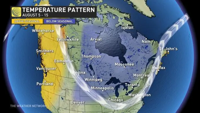
A significant pattern change looms as we enter into the month of August as we expect a reversal in the dominant jet stream pattern that will send cooler conditions into Ontario and Quebec. Temperatures however, look to remain warm through the long weekend and likely even stay a few degrees above seasonal, which is typically 27°C for this time of year.
"Though uncertainty is still high this far out, the current thinking is that temperatures will remain above seasonal through the long weekend, with the arrival of the pattern change holding off until later next week," says Weather Network meteorologist Dr. Doug Gillham.
MUST READ: Big pattern change sends millions into cooler territory for the start of August

SEVERE WEATHER COMPARISON FROM AUGUST 2018
At this point, it also looks like much of the weekend will be clear, which is quite the contrast from the severe weather that lashed the region on the holiday Monday last August. Torrential rain, powerful winds and even funnel cloud sightings were reported on Monday, August 6, 2018 as a line of strong thunderstorms moved through the area quickly.
The following day, August 7, the city of Toronto was swamped with 100+ mm of rain in less than three hours, causing extensive flooding over parts of the downtown core.
We will continue to watch for any active weather that could threaten this year's long weekend forecast, so be sure to check back in the days leading up to the weekend kickoff.


