Bomb cyclone ramping up in strength as B.C. begins to feel its wrath
The latest B.C. bomb cyclone will create additional disruptions on Wednesday as it continues to make its notable presence felt
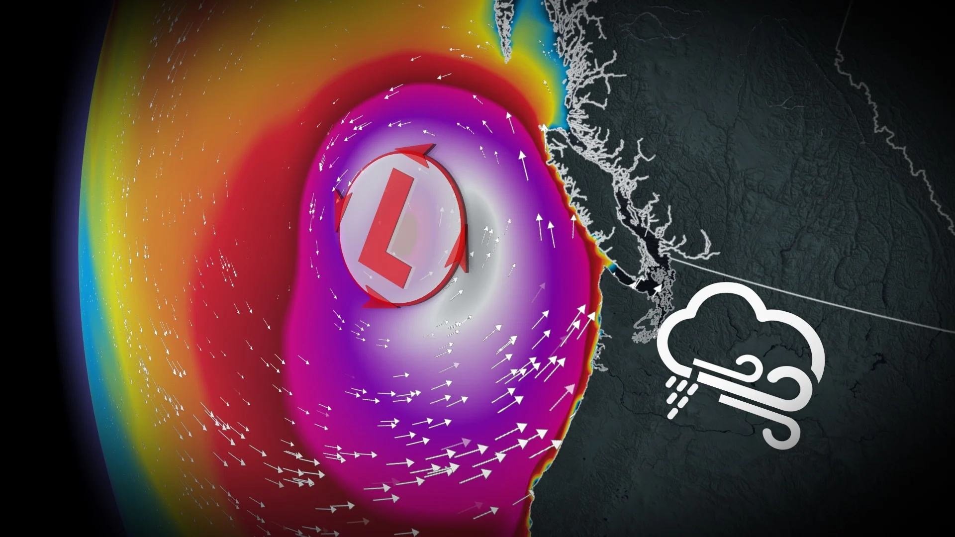
An exceptional, rapidly intensifying storm began to impact the B.C. South Coast late in the day on Tuesday. Expect a continuation of wind and alpine snow impacts to spill into Wednesday.
Despite the considerable effects, the storm is not coming ashore, so folks won't be getting the full brunt of the bomb cyclone. However, regions inland will certainly be feeling some of the wrath. Numerous alerts are in place, including wind warnings, special weather statements and weather advisories.
DON'T MISS: B.C. bomb cyclone to create the world’s largest wave pool
Damaging wind gusts are anticipated into Wednesday, so there is a high likelihood of more power outages and travel disruptions. On Tuesday, BC Ferries cancelled the evening's sailings between the Lower Mainland and Vancouver Island in anticipation of the storm. There is likely to be more interruptions on Wednesday.
Plan accordingly, especially when it comes to travel, and secure loose outdoor objects, and ensure your devices are charged, as well.
Heavy precipitation is also possible for some locations. In fact, some alpine locations could see more than 100 cm of snow by the end of Wednesday.
Bomb cyclone develops offshore
A strong jet stream aloft and sharp temperature differences worked together to rapidly intensify a low-pressure system off the B.C. coast. The minimum central pressure within this low could see an approximate 60 to 70-hPA drop in 24 hours.

SEE ALSO: Heavy snowfall in B.C. leads to early opening at Big White Ski Resort
This would double the criteria for bombogenesis, the formal name for the rapid intensification that leads to a bomb cyclone.
A bomb cyclone is different from other storms because the dynamics within a rapidly intensifying storm can create ripping winds and extreme precipitation rates.
WATCH: A brutal blizzard is building in B.C. alpine, nearly 200 cm forecast
Wednesday: Brace for outages, travel disruptions as winds continue to be strong
It’s going to be a long-duration wind event, so ferry delays and cancellations will spill into Wednesday. Breezy winds peak Wednesday morning in the Strait of Georgia and coastal Vancouver Island, and will remain gusty all day.
Gusts will generally peak at around 90-100 km/h.

What makes this even more interesting is how strong the winds will be for the east side of Vancouver Island from Nanaimo to Campbell River. Winds will be blowing from the southeast, but also paired with outflow winds for the mainland that will push those winds farther onshore than normal.
With the high pressure to the north, this will cause outflow winds in the north, as well, a bit early in the season for such a setup.
In addition to the winds, all local ski resorts are in line for copious amounts of snow.

Some areas could see close to 100 cm of snow from this event by the end of Wednesday.
RELATED: How a monster is born: Discover the fuse that lights a bomb cyclone

Widespread power outages are possible as a result of the high winds. Make sure you’re prepared in case the electricity goes out in your area.
Maximum wind gusts forecast:
Campbell River: 70-90 km/h
Comox: 90-100 km/h
Tofino: 90-100 km/h
Nanaimo: 70-90 km/h
Downtown Victoria: 70-90 km/h
Vancouver International Airport: 60-70 km/h
Delta: 70 km/h
Abbotsford: 60-70 km/h

Rainfall totals through Wednesday could exceed 100 mm near Tofino and western Vancouver Island, with 10-30 mm of rain for most other regions along the South Coast. Victoria will see under 10 mm of rain with a strong rain-shadow effect, courtesy of the Olympic Mountains.
Storm surge flooding may also be a concern for some locations. We’re just coming off a king tide cycle on Tuesday and Wednesday, so tides will be elevated right as the storm peaks. Some coastal inundation is possible Wednesday morning around communities like Victoria and Campbell River.
Stay with The Weather Network for all the latest on conditions across B.C.


