Brutal blizzard shaping up in B.C.'s alpine from bomb cyclone
A weather bomb, a rapidly intensifying storm, will provide the stage for what will become an exceptional snowfall event in B.C.'s alpine regions––even with the risk of thundersnow
While much of the attention has been on the near-record-breaking low pressure at sea level, the weather system heading for the alpine terrain is shaping up to be nothing short of legendary, and frankly, dangerous.
By Wednesday, a ski resort on Vancouver Island will be buried under an astonishing amount of snow. A deep, stalling low-pressure system combined with modified, Arctic air along the coast is forecast to deliver upwards of 100-150 cm of snowfall in just 36 hours.
RELATED: B.C. bomb cyclone to create the world’s largest wave pool

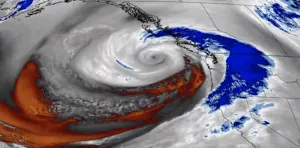
Nov. 19, 2024 satellite imagery of B.C. bomb cyclone. (RAMMB/CIRA/NOAA)
It should come as no surprise that the strongest blizzards are often tied to rapid cyclogenesis, and this event will be no exception. A weather bomb, a rapidly intensifying storm, will provide the stage for what will become an exceptional snowfall event, with even the risk of thundersnow in the alpine.
The wind forecast
When identifying blizzard conditions, wind speed is a key component. Sustained winds of more than 40 km/h are part of the official criteria.
So, what can the mountainous terrain expect on Tuesday night into Wednesday?

The forecast indicates strong winds will accompany the heavy snowfall, easily blowing the low-density snow around.
With temperatures well below freezing, this will not be a wet snow event. Instead, the light, powdery snow will further reduce visibility near the surface, creating hazardous whiteout conditions.

The snow forecast
For visibility to drop to near zero and meet the second blizzard criterion, intense snowfall rates are needed––and this storm will deliver in spades.
The secret lies in the dendritic growth zone, the atmospheric layer where snowflakes grow most efficiently.
Atmospheric soundings along the coast highlight significant lift occurring within this snowflake "factory," maximizing snowfall production.
As the flakes collide and clump together, phenomenal snowfall rates of 10–15 cm per hour are expected during the storm’s peak.

This setup will ensure a combination of fluffy, low-density snow and sustained high snowfall rates, meeting or exceeding blizzard criteria.
The timing
The third blizzard criterion, sustained conditions for at least four hours, will be surpassed. Blizzard conditions could persist for much longer, as the storm stalls and continuously pumps snow into the region.
The National Weather Service in Washington has issued a blizzard warning for the west slopes of the North Cascades.
How much snow?
To put this storm in perspective, many places in Canada don’t receive this much snow in an entire winter, yet it will fall in under 48 hours.

Travel implications: Some mountainous routes across the South Coast will be rendered impassable until the storm abates and road crews can restore visibility and safety.
Snow totals: With more than a metre of snow possible in isolated areas, this event will likely go down as one of the most significant storms of the season.


