Hurricane Milton targets Florida with life-threatening impacts as major storm
With an impending landfall this week, Hurricane Milton poses an 'extremely serious' threat to Florida, so residents are urged to follow the orders of local officials.
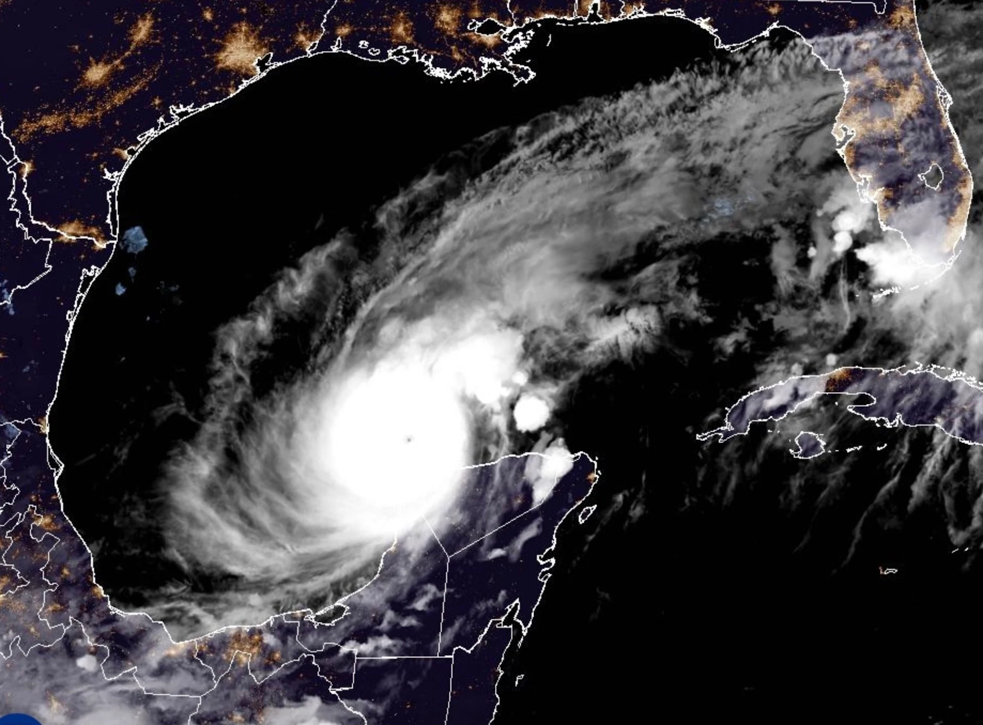
Milton's rapid transition to a powerful, dangerous storm has reached the highest level, prompting dire warnings from officials and the evacuations of some communities in the path of the large hurricane.
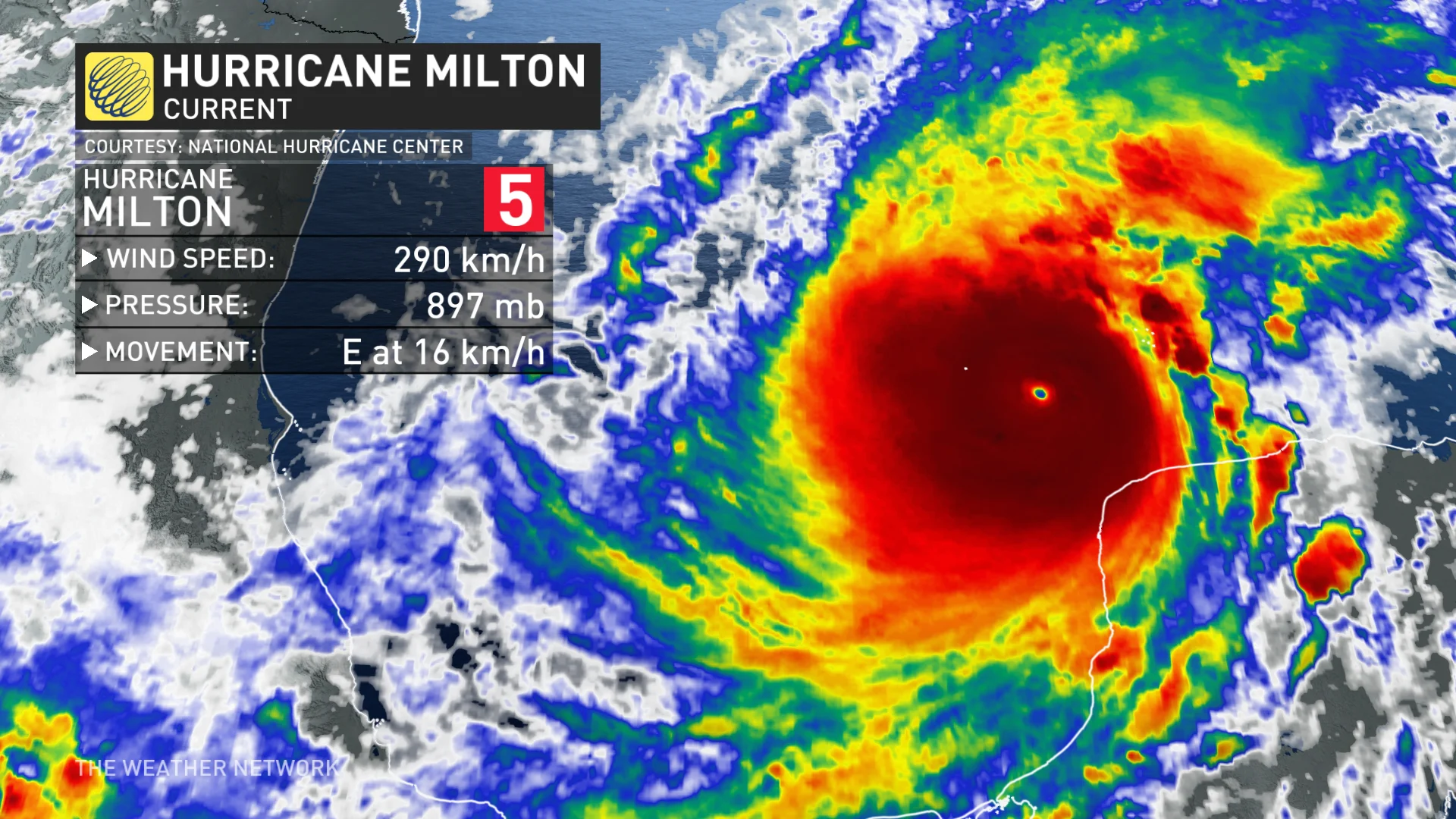
On Monday, it jumped from a Category 2 to a Category 5 hurricane within a matter of hours. It currently boasts maximum, sustained winds of near 285 km/h, with higher gusts, making it an "extremely serious threat" to Florida, according to the U.S. National Hurricane Center(NHC).
DON'T MISS: Nightmare scenario unfolding for Tampa with Milton's potential hurricane track
Hurricane and storm surge warnings have been issued for portions of the Florida's west coast. The storm surge warning is in effect from Flamingo northward to the Suwannee River, including Charlotte Harbor and Tampa Bay. The hurricane warning has been issued from Bonita Beach northward to the mouth of the Suwannee River, including Tampa Bay.
A hurricane watch in Florida stretches from Chokoloskee northward to the mouth of the Suwanee River, including Tampa Bay, the Dry Tortugas and Lake Okeechobee, as well as from the St. Lucie-Indian River County Line northward to the mouth of the St. Marys River.
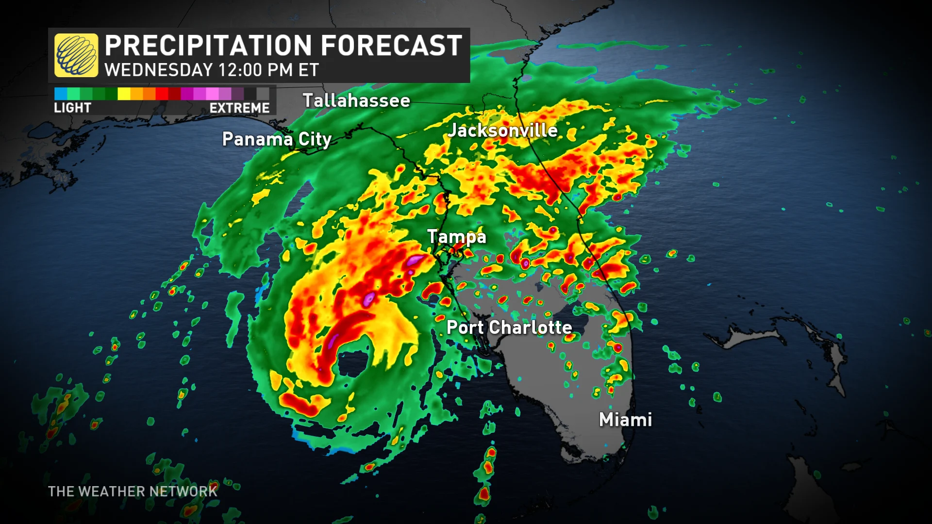
Widespread flash flooding in anticipated occur before and during the storm. Communities in Milton’s path can expect destructive winds, a life-threatening storm surge, and a risk for tornadoes as the storm hits the region.
Largest evacuation since 2017
On Sunday, Florida prepared for what's being called its largest evacuation since 2017 when Hurricane Irma hit. Anyone in Florida this week should take this storm seriously and closely monitor the latest forecasts and alerts from local officials. A mandatory evacuation has been issued for Fort Myers beach.
"I highly encourage you to evacuate," Kevin Guthrie, director of Florida's emergency management division, told Floridians in a weekend press conference.
Florida, and much of the Deep South are still recovering from the widespread devastation and destruction caused by Hurricane Helene, which killed more than 200 people across six states late last month.
As well, the Tampa Bay branch of the U.S. National Weather Service said on X that if Milton stays on its current track, it will be the worst storm to impact the Tampa area in more than 100 years.
Florida braces for Milton, millions urged to evacuate
Milton developed on Saturday and quickly intensified into a hurricane during the day on Sunday.
Favourable environmental conditions, along with very warm ocean waters, have allowed the system to continue intensifying as it heads east toward Florida. The storm rapidly picked up major hurricane status early Monday morning, with additional strengthening that led to a Category 5 upgrade by 12 p.m.
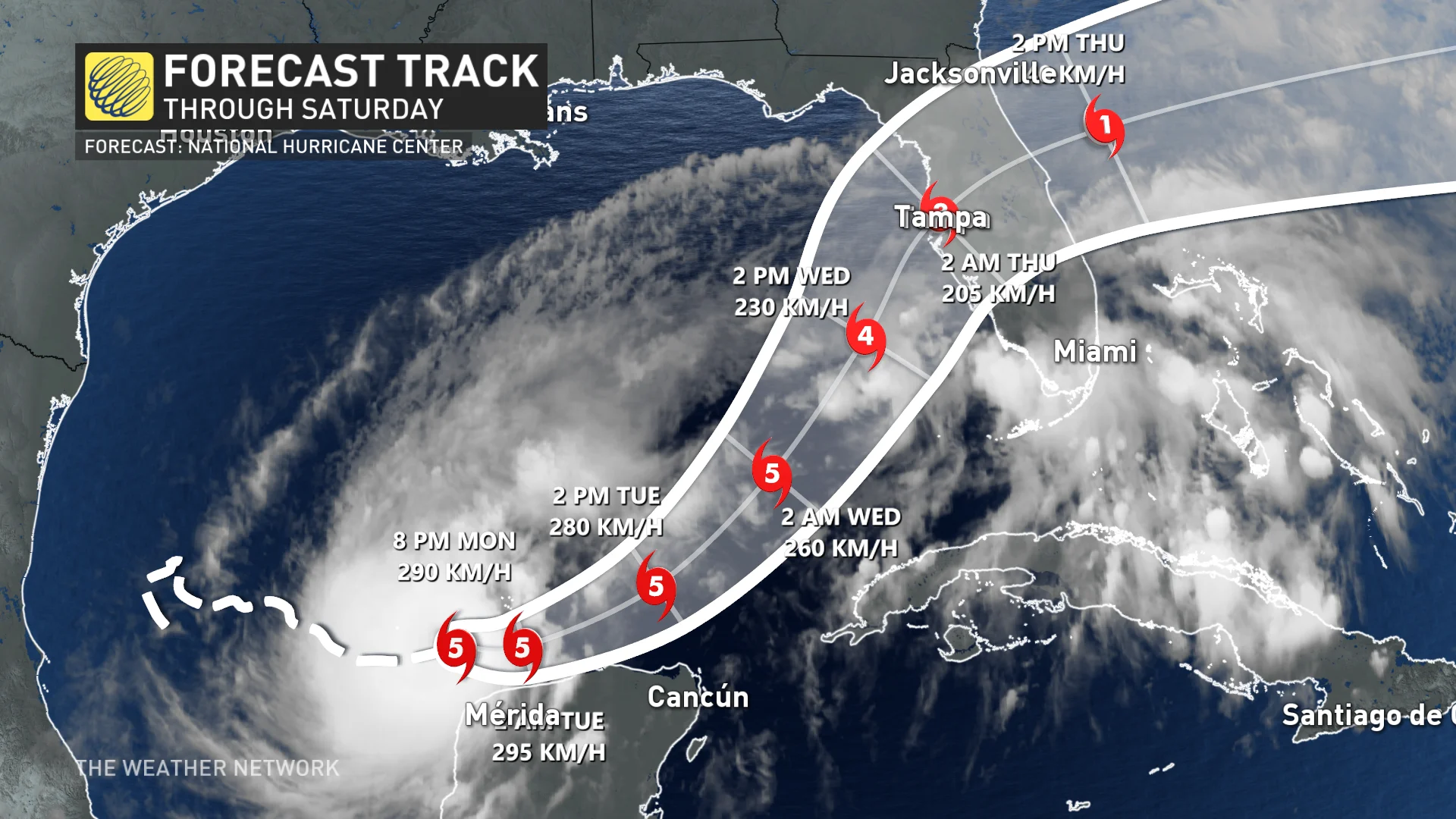
A landfall along Florida's west coast is likely Wednesday night through the overnight period. While fluctuations in intensity are expected, Milton is forecast to remain an extremely dangerous hurricane through landfall in Florida.

The storm is going to take an unusual path. Only a few storms in recorded history have ever moved from the southwestern Gulf east toward Florida. This track will maximize the amount of warm water Milton traverses before reaching land.
On the forecast track, the centre of Milton is forecast to move near or just north of the Yucatan Peninsula through Tuesday, then cross the eastern Gulf of Mexico and approach the west coast of the Florida Peninsula on Wednesday.
RELATED: Why Florida’s west coast is so vulnerable to storm surge flooding
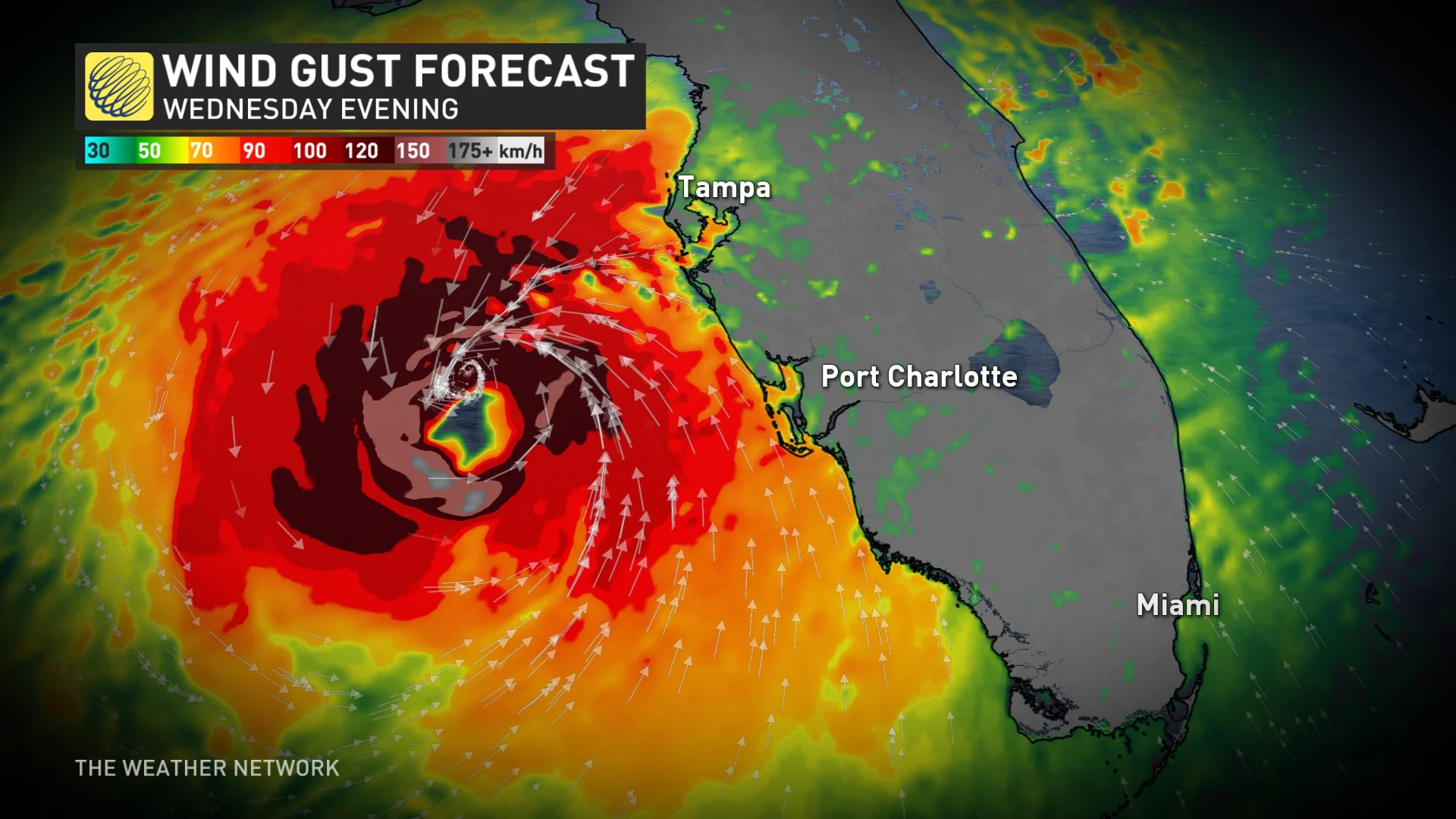
The precise landfall location is still uncertain right now. Milton’s powerful core could move ashore anywhere from Fort Myers in the south to the hard-hit Big Bend region to the north. Landfall could end up somewhere near Tampa Bay, Sarasota, or Cape Coral.
It’s worth noting that the storm’s strength and fast-forward speed would bring strong winds well inland across Florida. Depending on the track, this could bring dangerous winds into the Orlando metro area and portions of Florida’s east coast, as well.
A dangerous situation for Florida
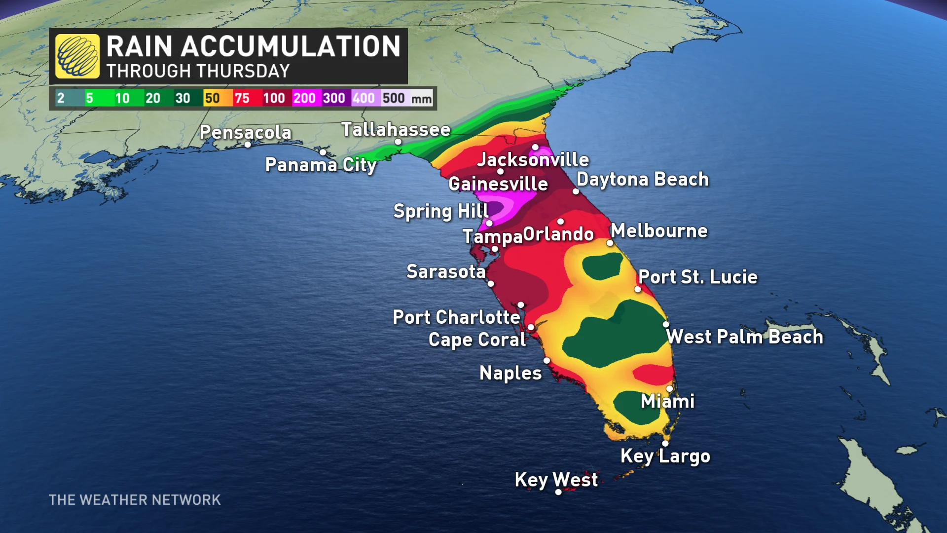
Widespread, flooding rains will begin well ahead of Milton’s arrival this week. Most of the Florida Peninsula is in line for several days of very heavy rainfall that’ll culminate in the hurricane’s arrival on Wednesday.
A surge of tropical moisture will collide with a stationary front parked over Florida to begin the week. This front will help wring out the excess moisture in the atmosphere, leading to a long period of heavy rains before Milton’s landfall.
This slug of pre-storm rainfall is somewhat similar to what we saw ahead of Hurricane Helene late last month. Many communities throughout Florida could see 125-250+ mm of rain during this event. Some localized areas could even see up to 380 mm.
Milton will also produce rainfall totals of 100-175 mm across the Florida Keys through Thursday.
MUST SEE: Why focusing on a hurricane’s category is downright dangerous
"This rainfall brings the risk of considerable flash, urban, and areal flooding, along with the potential for moderate to major river flooding," NHC warned in its latest statement.
Powerful winds in the core of the hurricane will cause significant damage near the point of landfall. Damage to homes and businesses is likely, along with long-lasting power outages in the hardest-hit communities.
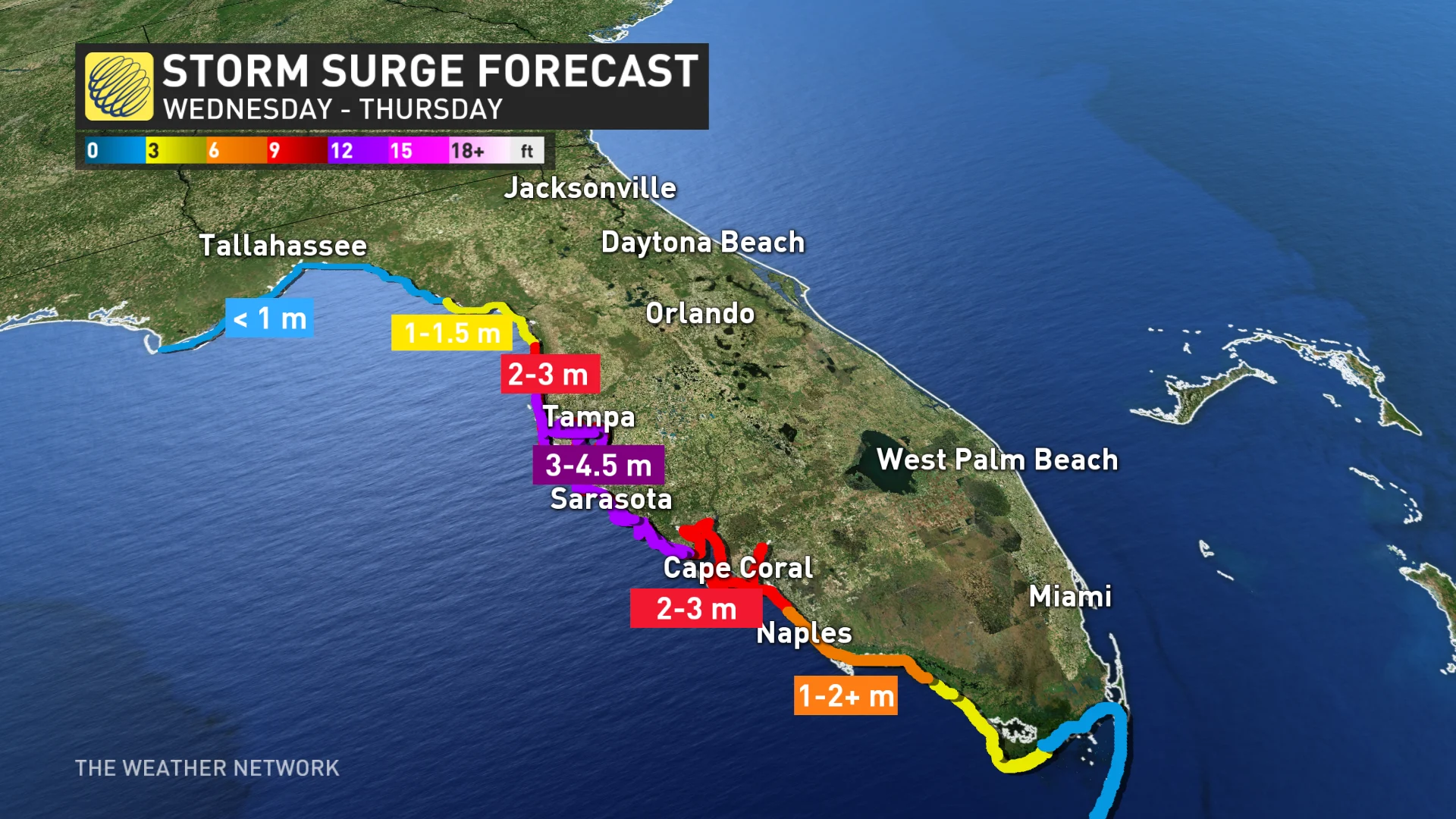
A life-threatening storm surge is likely where the hurricane makes landfall. Florida’s western coast is exceptionally vulnerable to storm surge flooding. Depending on the hurricane’s ultimate track, this could be a very dangerous situation for the Tampa Bay area.
"The combination of a dangerous storm surge and the tide will cause normally dry areas near the coast to be flooded by rising waters moving inland from the shoreline," NHC warns.
In Tampa Bay, water heights could reach 3-4.6 metres above ground. The deepest water will occur along the immediate coast near and to the south of the landfall location, where the surge will be accompanied by large and dangerous waves.

Florida Gov. Ron DeSantis is warning of a potentially higher storm surge and more power outages from Milton compared to Helene, with damage from Helene likely to be compounded.
"There are some areas with a lot of debris that is there, so if you get hit with a major hurricane, what's going to happen to that debris? It's going to increase the damage dramatically," DeSantis said in a news report from Reuters. "This is all hands on deck to get that debris where it needs to be."
As with any landfalling tropical system, tornadoes will also pose a threat to the Florida Peninsula as Milton makes landfall this week. Stay alert for tornado watches and warnings throughout the state. Tropical tornadoes can happen quickly with reduced tornado warning lead time.
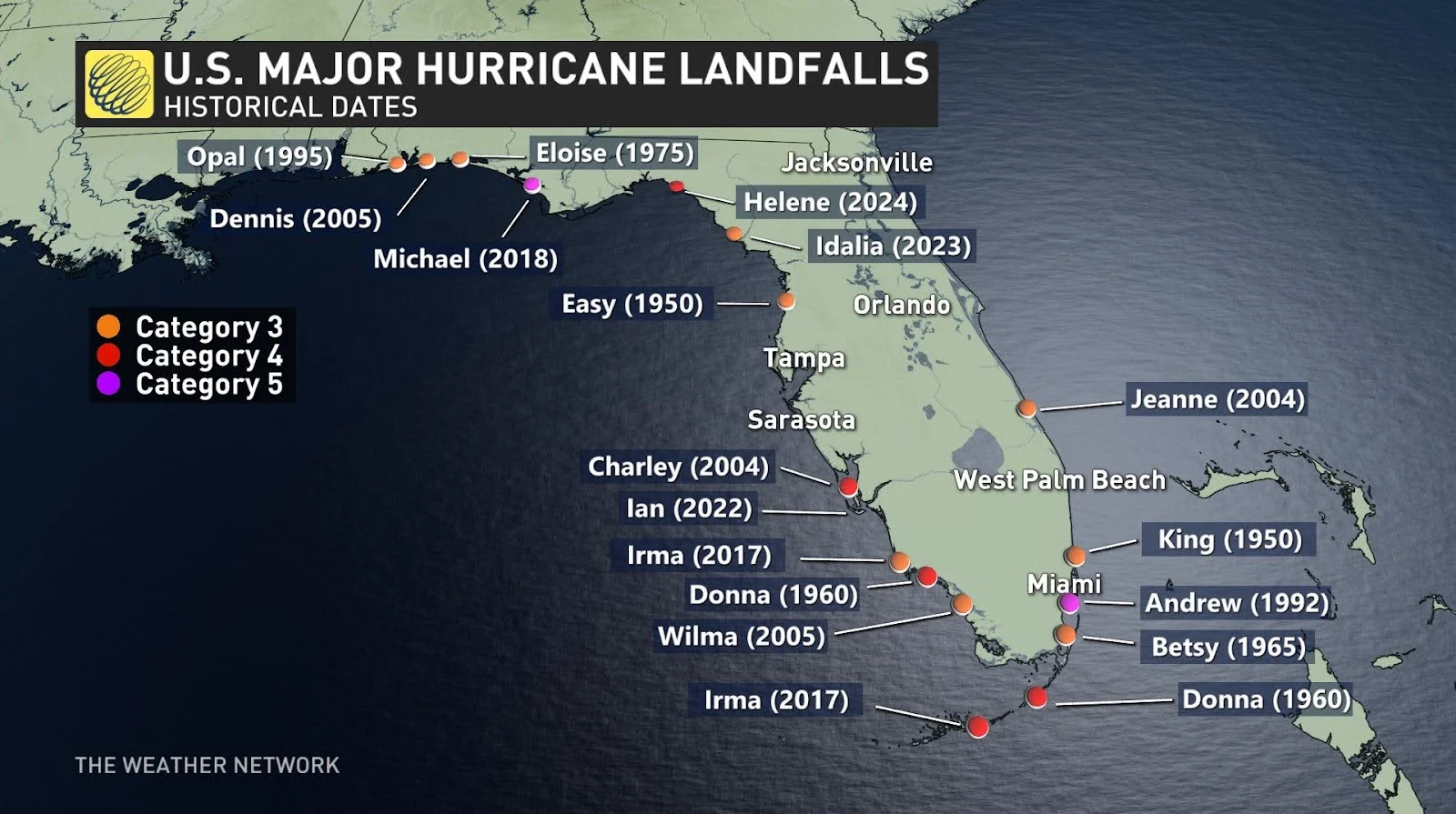
It's also worth noting that this is a rare situation overall. A major hurricane hasn't directly hit the Tampa Bay area in living memory. The last major hurricane to strike the region occurred back in 1921.
Hurricane season officially above average
The Atlantic hurricane season now has 13 named storms, with the average being 14. However, we are now one hurricane and one major hurricane above normal.
DON’T MISS: 2024 Atlantic hurricane season is officially above average with 12th named storm
Even though we’ve had a slower-than-expected hurricane season so far this year, it’s been a destructive year in terms of landfalls across the United States. If the forecasts pan out, Milton would be the fifth hurricane to make landfall along the U.S. Gulf Coast since early July.
WATCH: Intense scenes in the hours after Helene made landfall
With files from Reuters
Thumbnail courtesy of NOAA.