Lake Effect Snow: Will it continue the whole winter?
The Great Lakes are still open for business and lake effect snow continued this week in Ontario.
HOW DOES LAKE EFFECT SNOW HAPPEN?
Lake effect snow is common across the Great Lakes region during the late fall and winter. It can happen when cold air from the north moves across the open warm waters of the Great Lakes. The air rises, clouds form and grow into narrow bands of snow that that produce some of the biggest snow events of the season. The typical 'lake effect snow season' is the late fall and winter but we can get Lake Effect snow right into the spring if we have the exact temperature profile needed to create the magic. Could this happen this year? It's possible, read on.
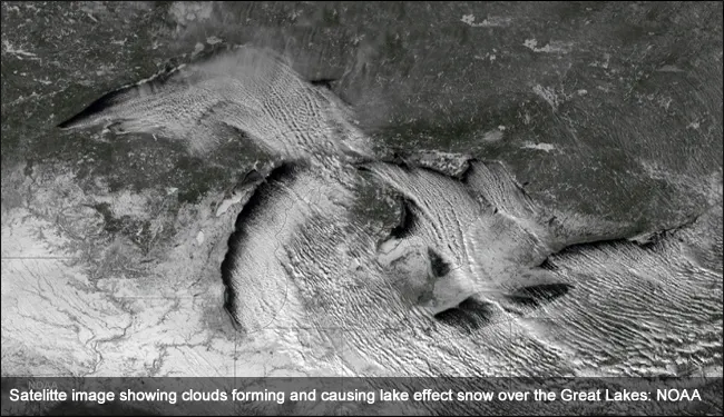
Courtesy: NOAA
HOW WARM OR FROZEN ARE THE LAKES RIGHT NOW?
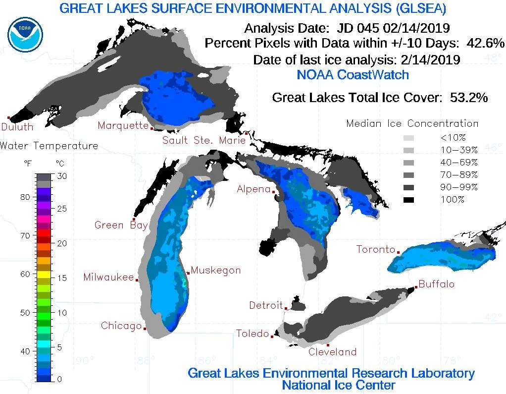
Lake Erie is typically the warmest of the Great Lakes due to the fact that it is the most shallow -- it is also the first to typically freeze. As of February 15, 2019, it is 71% frozen which is less coverage than on February 11, 2019, when it had 92% coverage. Lake Ontario is still only at 16.99% as of February 15, 2019, and has not gone beyond 35% so far this season, which is pretty normal.
However, lake effect snow needs more than just a lack of ice coverage in order to develop. Temperatures also play a vital role. There must be a minimum 13º C temperature difference between the lake and the air approximately 1.5 km up in the atmosphere. Without this difference, lake effect convection cannot happen. As the winter goes on and the lakes cool and freeze, it becomes more difficult for lake effect snow to develop. However, through the winter the air temperature aloft is also becoming colder so lake effect snow is possible right through the winter if the lake remains open; it just becomes more difficult to happen.
Lake Superior and Lake Huron are continually cooling and have more overall ice coverage and are colder because they are further north and tend to be geographically placed within many more of our cold air outbreaks this season despite being the biggest of all the Great Lakes.
IS IT NORMAL TO GET LAKE EFFECT SNOW IN FEBRUARY?
It is February, and yes, we continue to see bands of lake effect snow stream in to parts of Ontario. Is it normal for our lakes to be as ice free this late in the season? Yes, if you compare it to the last few years.
Last year, the percentages of ice coverage on some of the Great Lakes were pretty close to what they are this year. However, in 2014 the year of the Polar Vortex, it was very different. All the lakes were virtually frozen, shutting down the lake effect snow machine earlier in the season. In early March of 2014, the overall Great Lakes ice extent reached 94.19%, the second most on record for any month, dating back to 1973 in NOAA’s dataset, and most on record so late in the season.
According to meteorologist and long range forecaster Dr. Doug Gillham, we'll see the potential return of frigid arctic air as head into March. If this does happen, as long as there is a temperature difference of 13ºC between the Great Lakes and the air aloft, you can expect to see more lake effect snow events across Ontario.
Stay tuned to The Weather Network for the latest as we close on the Winter 2019.
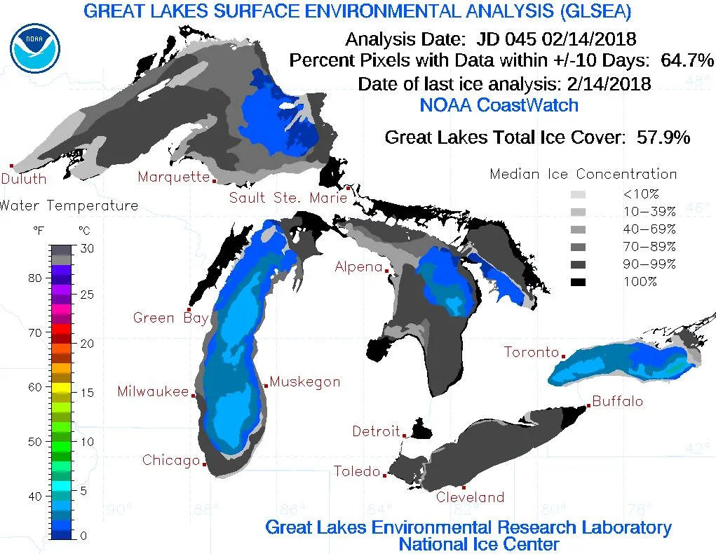
Courtesy: NOAA
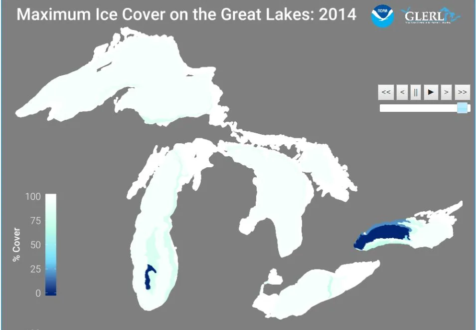
Courtesy: NOAA


