
Torrential rain and flooding lead to rising total of power outages in Ontario
The threat for additional thunderstorms spreads across parts of Ontario for Tuesday before the heat breaks and more seasonal conditions return heading into the weekend. Brace for heavy downpours and strong winds throughout the day
Monday's thunderstorms were a washout, with flash flooding reported across southern sections of Ontario. The same storm threat continues well into the day on Tuesday, with flooding rains accompanying the risk throughout the day.
Some communities saw significant rainfall rates of 30 mm in just 30 minutes during the morning hours, resulting in dangerous flooding on several roads and highways. On Tuesday morning alone, Toronto's Pearson International Airport picked up 97.8 mm of rain.
"This is (so far) the fifth-wettest day, and third-wettest July day on record," said Matt Grinter, a meteorologist at The Weather Network. "The wettest day on record brought 126 mm on July 8, 2013, when there was also major flooding in Toronto."
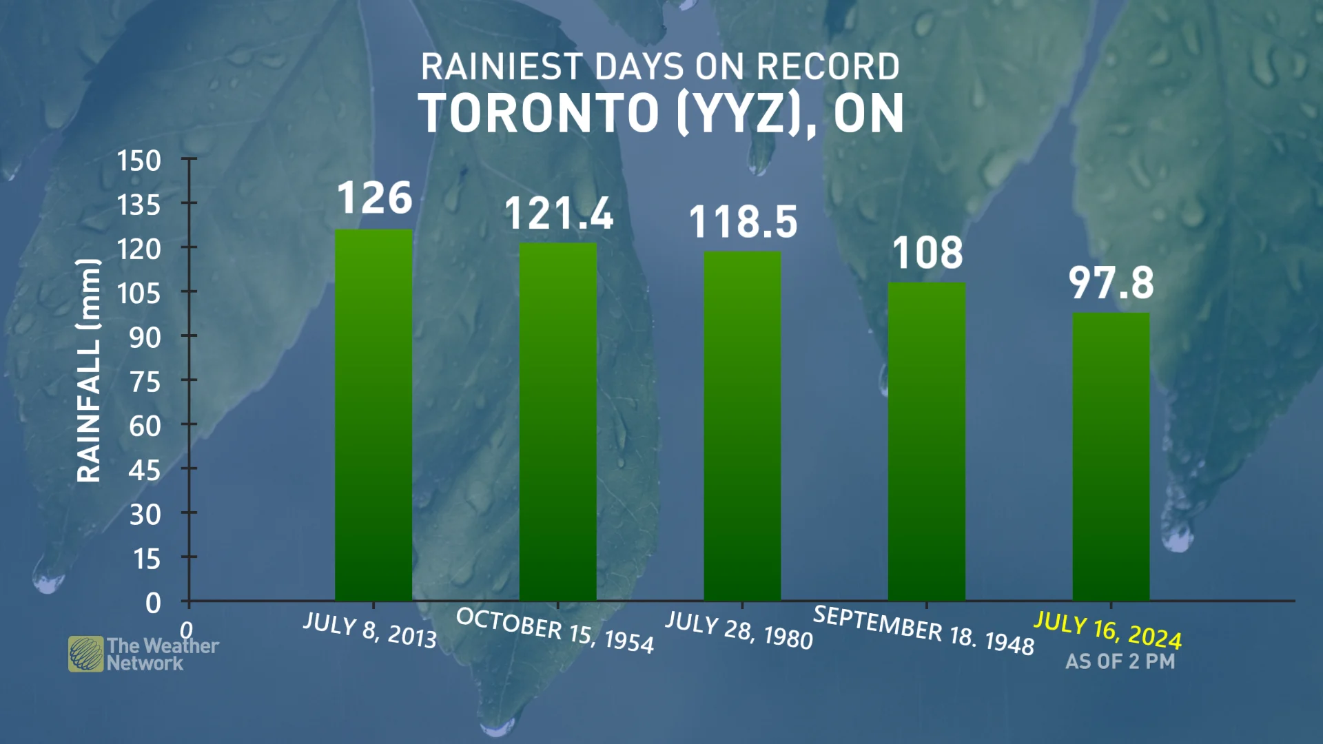
Rainfall totals in Toronto as of 2 p.m. EDT on July 16, 2024. (The Weather Network)
That flood risk will continue for much of the day, especially in places that see training thunderstorms, which can produce a lot of rain in just a short period of time over the same areas. Rainfall warnings are widespread.
Strong wind gusts and large hail are also threats with storms that develop, once again.
DON'T MISS: 'Training' thunderstorms lead to flash flooding in Ontario, but what are they?
Power outages across southern Ontario are growing, with much of them based in Toronto. The local electricity agency in Toronto is reporting 165,000 customers are in the dark as of early Tuesday afternoon.
Keep a close eye on the radar throughout the day across southern and eastern Ontario, especially if your plans take you outdoors. Never try to drive across a flooded roadway. It’s impossible to tell how deep the water is until it’s too late.
The chance for isolated storms will persist into Wednesday, though not as severe as what kicked off the work week. Temperatures will also fall into more seasonable values, providing relief from the extreme heat as we head into a pleasant weekend.
Tuesday: Thunderstorm chances bubble up once again, risk of heavy rain and strong winds
Rounds of thunderstorms are forecast once again on Tuesday as the low brings a cold front into Ontario and southern Quebec.
A cluster of storms prompted warnings as they first worked their way across the southwest early in the day, pushing into the Greater Toronto Area (GTA) in time for the morning commute. Heavy downpours brought quick and significant rain accumulations, with some areas threatened with significant totals between 40-80+ mm. As much as 100 mm could fall in the hardest-hit spots, including Toronto's Pearson Airport, which had picked up 96 mm by 12 p.m.
PHOTOS: Flash floods batter southern Ontario, cause chaos on the roads
"It’s almost blizzard levels of whiteout south of Guelph in the line of storms," said Storm Hunter, Mark Robinson out on the roads Tuesday morning.
Drivers are urged to adjust travel plans in affected areas, as heavy rains can cause flash flooding and ponding of roads. Local flooding is possible in low lying areas.

Toronto and Region Conservation Authority (TRCA) has issued a Flood Warning, with rivers within the GTA experiencing higher than normal water levels and greater flows. All shorelines, rivers and streams within the GTA should be considered dangerous.
"Avoid all recreational activities in or around water at this time, including fishing, canoeing, hiking, etc, as conditions can change rapidly," the TRCA warns. "Please exercise caution if you must be around any bodies of water, rivers or streams as well as the Lake Ontario shoreline."

Another round of storms are expected through the afternoon, and these storms will likely extend from southern Georgian Bay to Toronto and into the Niagara region.
Storms will also track down the Ottawa Valley into the afternoon and evening, with the potential for these storms to turn severe across the region. Any storms that develop could produce isolated damaging wind gusts, heavy rain, and large hail. Extensive lightning could also accompany the storm threat.
DON'T MISS: How severe weather alerts are issued, and potentially save lives
Storms that track into eastern Ontario have the potential to bring rotation, however there is lower confidence in that occurring.
Regardless, it'll be important to stay weather-aware at all times, as conditions can turn quickly when severe weather hits.

Rain eases mid-week, but not completely in the clear
From Wednesday onward, high temperatures are expected to return to seasonably warm values, breaking the extreme heat that has spread through for most of this month so far.
SEE ALSO: Two 'surprise' tornadoes hit southern Ontario as Beryl remnants passed through
While not as stormy as Monday and Tuesday, there will still be some instability with a trough tracking through Wednesday, bringing isolated showers or thunderstorms across southern Ontario.
WATCH: Messy storm brings heavy rain to southern Ontario
Thursday will be partly sunny and cool, with a gusty northwest wind and high temperatures mostly in the lower 20s, but some southern areas will still reach 24 or 25°C. A passing shower is possible, but most of the day will be dry, with Friday bringing mostly sunny conditions and high temperatures into the 20s.
It's looking like some gorgeous summer weather for Saturday once again, as abundant sunshine and seasonal temperatures with highs in the upper 20s splash through.
Beyond the weekend, no significant heat is expected into next week, as well as a somewhat drier pattern than what we have seen for most of the summer so far.
Stay with The Weather Network for all the latest on conditions across Ontario.
Header image courtesy of Mississauga Fire/X