Ontario: Rainy, windy system moves in with cool temperatures
Below seasonal temperatures are set to linger throughout the weekend, and a rainy low pressure system will likely bring some disappointment to those that are waiting for consistent spring warmth.
Below seasonal temperatures are set to linger throughout the weekend, and a rainy low pressure system will likely bring some disappointment to those that are waiting for consistent spring warmth. Patchy weekend clouds across southern Ontario will hide the sun and also carry the potential for late Sunday rain showers. We take a look at high water levels in the Great Lakes, who can expect to warm up this weekend, and if you'll be giving mom the gift of good weather (hint: get a back-up present) this weekend, below.
Visit our Complete Guide to Spring 2019 for an in depth look at the Spring Forecast, tips to plan for it and much more
WEATHER HIGHLIGHTS
High pressure means clearer skies Saturday
Risk of showers returns for Mother's Day for some
Increased flooding risk along shores of lakes Erie, Ontario with strong winds and high waters
Latest watches and warnings HERE
WATCH BELOW: COOL TEMPERATURES DOMINATE IN SOUTHERN ONTARIO
The chilly air has returned to southern Ontario, courtesy of high pressure bringing down cold air from the north. That high pressure will bring sunny skies for many on Saturday, but it has also prompted frost advisories for parts of the southwest into Saturday morning.
The brisk temperatures will remain about five degrees cooler than seasonal across most of the southern tier of the province, thanks to an east wind off of lakes Ontario and Erie. Unfortunately the clear conditions will be short lived, as clouds will move in throughout the day and will remain throughout the weekend.
WATCH BELOW: TRACKING THE RETURN OF RAIN FOR MOM'S BIG DAY
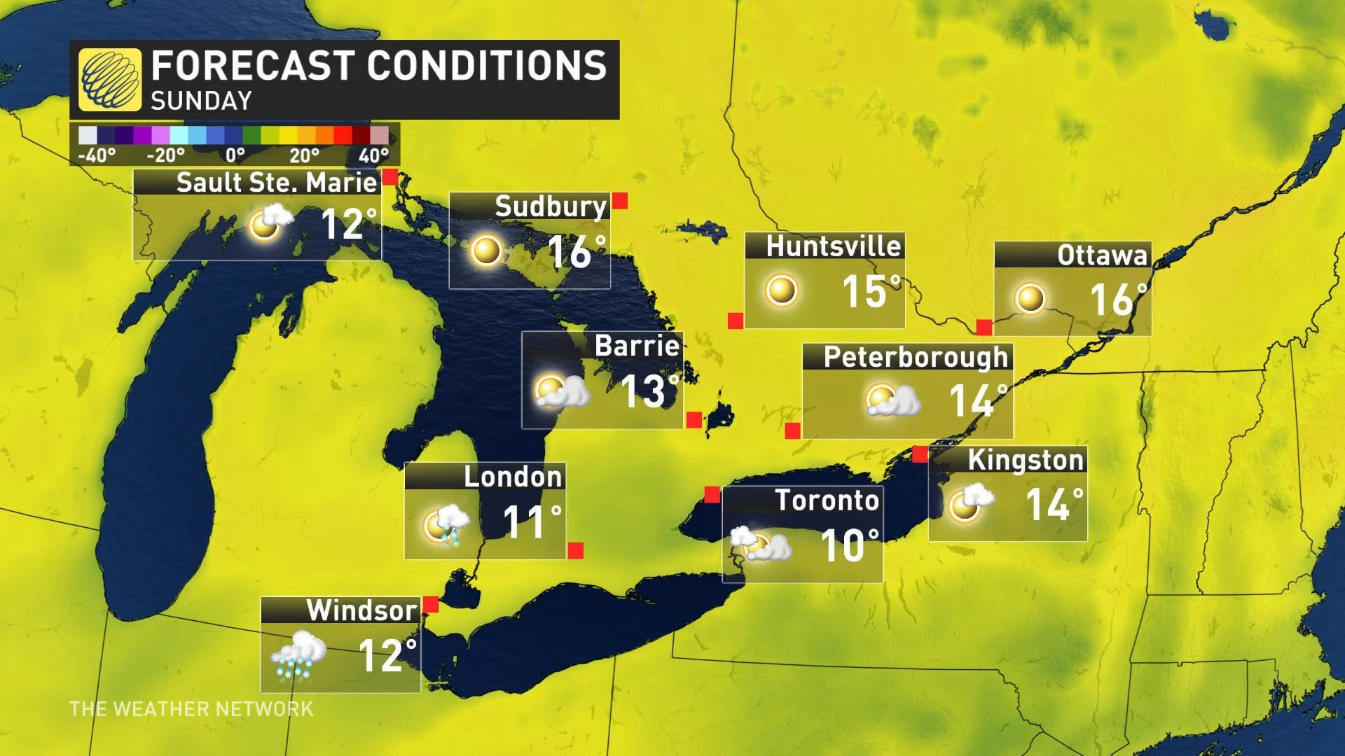
A system skimming southern Ontario to the south will bring the threat for showers back into the region on Mother's Day, though it's expected to remain largely south of the border -- good news for those with outdoor plans.
"Expect light rain totals during the day on Sunday, and there will be rain-free periods," says Weather Network meteorologist Dr. Doug Gillham. Even where the showers hold off until later in the day, clouds will be increasing.
With that said, those strong east winds persist across the lakes on Sunday, and that means much of the GTA, 401 corridor, Niagara and the southwest will remain on the chilly side of seasonal.
It's actually central and eastern Ontario and the Nickel Belt who stand to see the nicest weekend weather, as temperatures rebound comfortably into Sunday.

RELATED: Watch? Warning? See what you need to know about the difference
LAKE ONTARIO, ERIE FLOODING CONCERNS
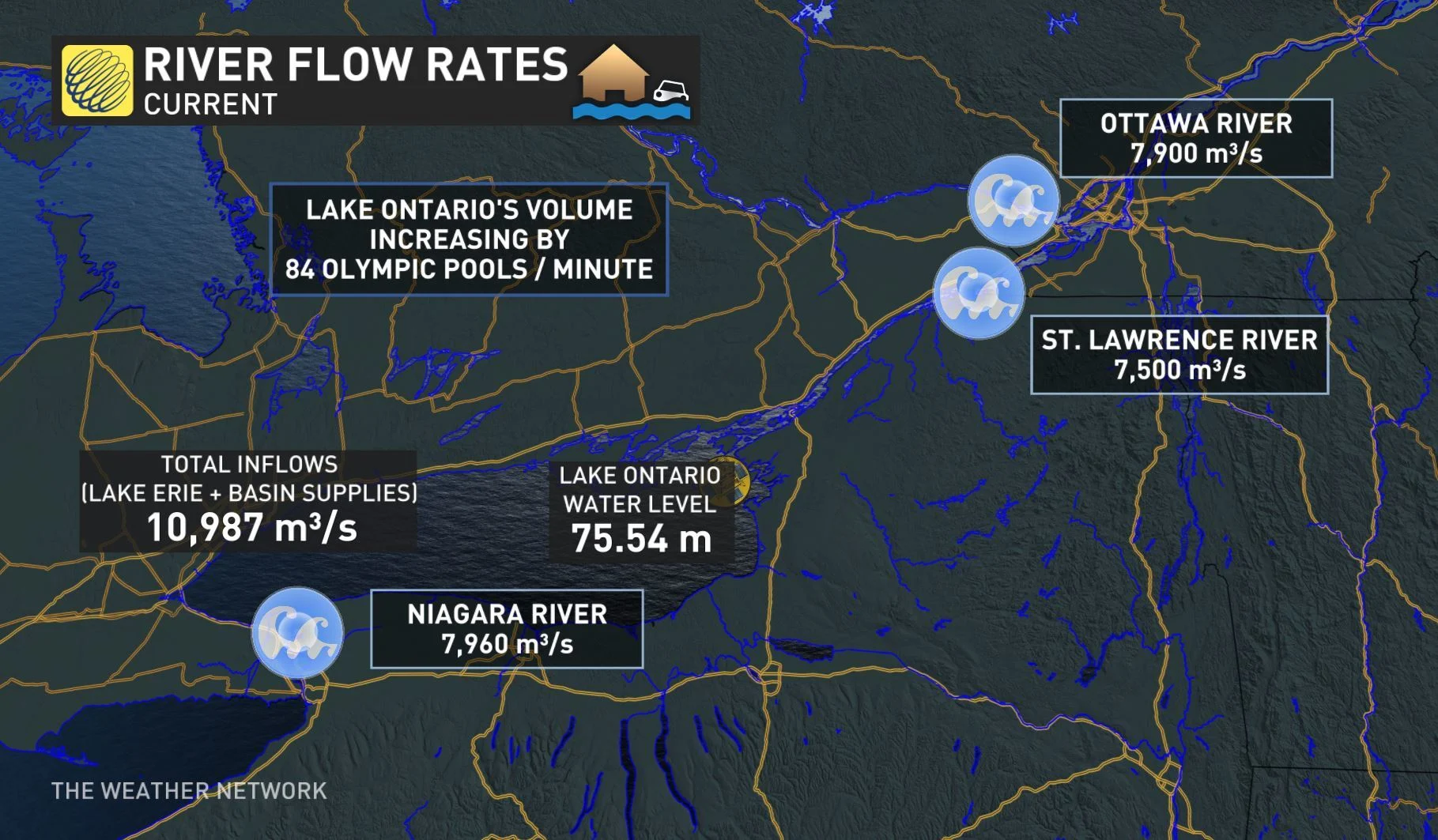
Water levels in Lake Ontario have topped 75 metres and are currently sitting at 75.55 m -- about 30 cm shy of the severe flooding levels that swamped the Toronto Islands in 2017.
The body responsible for regulating flow from the lake -- the International Lake Ontario – St. Lawrence River Board -- expects water levels to continue rising until late May or early June, and puts the forecast peak somewhere between 75.65 to 75.95 metres. That would top 2017's record levels by about two centimetres.
"Water levels will continue to rise about a centimetre every single day," warns Weather Network meteorologist Tyler Hamilton.

The shoreline hazard warning issued last week by the Toronto and Region Conservation Authority (TRCA) was renewed on May 7 and is set to remain in effect until further notice. The TRCA has also issued a notice of caution specifically for the Scarborough Bluffs due to the potential of landslides.
The Essex Region Conservation Authority has also issued a flood watch for shorelines along Lake Erie and the shores of Pelee Island. Officials say both Lake St. Clair and Lake Erie started the month with above record high water levels that were reached in 1986.
READ MORE: Toronto Islands face another year of significant flooding as lake waters rise


