Canada's 2024 Fall Forecast: Will autumn end with a free fall into winter?

Fewer fall storms are expected through October for most of Canada, but pattern changes will likely be accompanied by high-impact storms as the season progresses.
All of Canada experienced an early taste of fall weather this year, but that was followed by a strong summer comeback across most of the country. Is this summer’s grand finale, or will warm weather linger well into the fall season?
The transition to consistent cool weather will be slower than what we typically see across most of Canada. Extended periods of pleasant fall weather are expected to last well into October, especially across the eastern half of the country. However, we are closely watching the potential for an abrupt transition to a colder pattern before the end of the fall season.
Keep in mind that changeable weather is the trademark of the fall season, and this year will be no exception. However, throughout this temperature roller coaster, the periods of warmer than normal temperatures are expected to be more dominant than the shots of colder weather for areas east of the Rockies. Meanwhile, for British Columbia and the Yukon, the alternating periods of above and below seasonal temperatures should come close to offsetting each other.

An active pattern along our Pacific coast is expected to deliver above-normal precipitation totals to southern British Columbia and into southern Alberta. Above-normal precipitation is also expected across much of Northern Canada and for southern parts of Atlantic Canada.
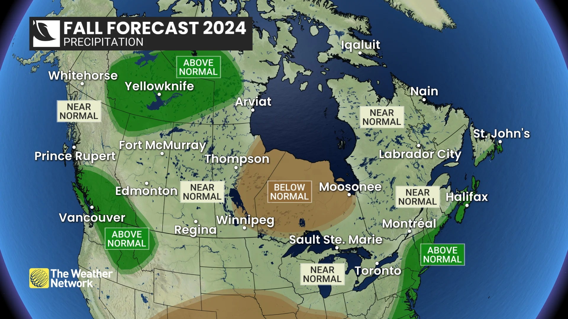
Otherwise, we expect that the rest of Canada will experience fewer than normal fall storms through October. However, the storms that do occur could still pack quite a punch, and both coasts will have a heightened risk of excessive rain events. A stormier pattern is expected to develop across Canada as we transition into early winter.
DON'T MISS: Get more fall preparation tips from The Weather Network's Seasonal page!
La Niña holds the keys to November
One of the key variables that will impact the jet stream and the resulting weather patterns during the fall season is the developing weak La Niña conditions in the tropical Pacific Ocean. La Niña is characterized by cooler than normal ocean weather temperatures near the Equator to the west of South America.
When we look back at other years with a similar pattern heading into fall, we see that most of those years had a warmer than normal fall across Canada through the month of October. A few of those years remained mild through most of November before transitioning to a colder December. However, many of those years saw an earlier and rather abrupt pattern change, resulting in a rather chilly November across most of western and central Canada.
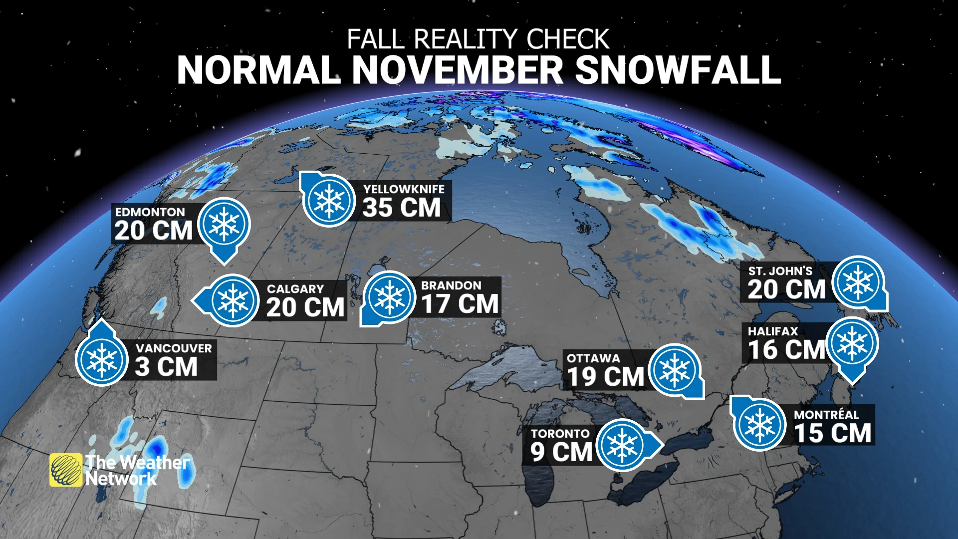
November snowfall averages across some of Canada's major cities. (The Weather Network)
Closer examination reveals that when the coolest water relative to normal is located just to the west of South America, we tend to see a much earlier pattern reversal, leading to a cold November.
RELATED: Visit The Weather Network's La Niña and El Niño hub for latest news
However, during years in which the coolest water relative to normal was found towards the central Pacific, the warmer pattern dominated through most of November before trending cooler for December.
Which will be this year? The signals are mixed, and the reality is that we could see a blend of the two different scenarios.
As a result, the timing of the pattern change is uncertain, but it appears unlikely that we will coast through the entire fall season without a significant taste of the season to come, which of course is winter.
Below is a more detailed look at the conditions that we expect across Canada this fall.
British Columbia
After a cool conclusion to August, summer delivered an impressive grand finale during early September with mid-summer-like heat and record-breaking temperatures. As we look ahead to the remainder of September, October, and November, we expect that we will settle into a more typical fall pattern. Alternating periods of mild weather and periods of cooler weather should come close to offsetting each other. However, the B.C. Peace region and the Rockies are expected to tip to the mild side of seasonal.
An active storm track into the south coast region in combination with warmer than normal ocean water temperatures in the north Pacific should deliver above-normal precipitation totals to the southern half of the province, including Vancouver and Victoria, along with a risk for an excessive rainfall event. However, this pattern should also support a much stronger start to the ski season than we saw last year.
WATCH: B.C.'s 2024 Fall Forecast
Alberta
Late August and early September have dramatically illustrated the changeable nature of this time of year across Alberta, with record-breaking heat interrupted by shots of much cooler weather. Changeable temperature patterns will continue through the season, but overall we expect that warm periods will outweigh the periods of colder weather across the province, including Edmonton and Calgary.
However, anyone who has lived in Alberta for very many years knows all too well that high-impact winter weather shows up during most fall seasons, including the ones that end up mild overall. It is unlikely that year will be an exception. October could very well deliver some winter weather, but we do not expect that cold weather will lock in until later in November or December.
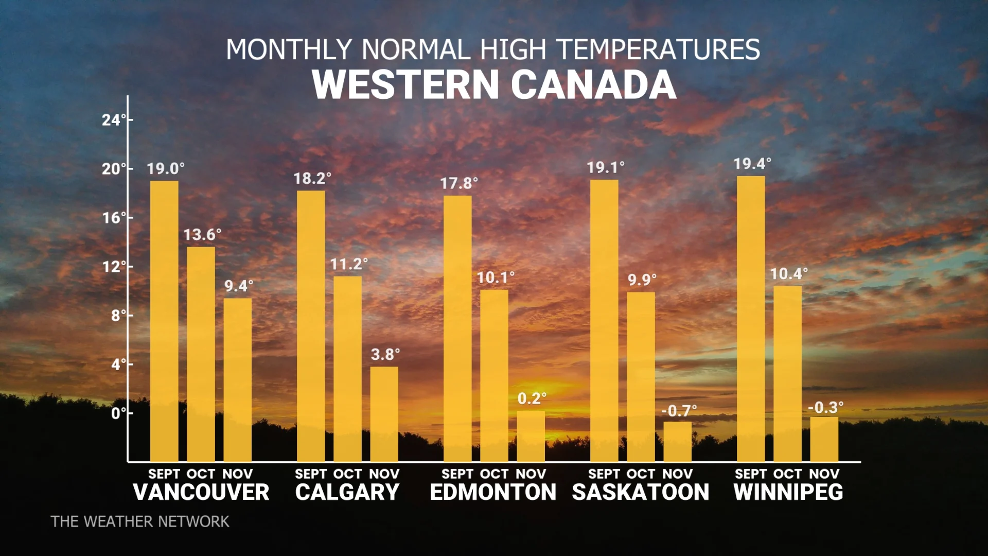
Average temperature highs across parts of Western Canada. (The Weather Network)
However, once the transition to a consistently cold pattern occurs, we expect an extended stretch of colder than normal temperatures into the start of winter.
Near-normal precipitation totals are expected across most of Alberta, but above-normal totals are expected for southwestern parts of the province.
WATCH: 2024 Fall Forecast for Alberta, Saskatchewan and Manitoba
Saskatchewan and Manitoba
The past few weeks have featured a temperature roller coaster, but overall warmer than normal temperatures have dominated. We expect that pattern will continue to be the theme for the remainder of September and October across this region. That will include additional summer heat during mid-September for southern parts of the region, including Winnipeg and Regina.
However, a warmer than normal fall certainly does not rule out some winter weather, as “normal” temperatures rapidly fall through the season. But any shots of cold weather during October are expected to be temporary.
We do not expect that cold weather will lock in until November or possibly December, but we do expect an abrupt transition to a more consistently cold pattern before the end of the season, followed by an extended stretch of colder than normal temperatures as we head into early winter.
Near-normal precipitation is expected across most of the region, but eastern parts of Manitoba are expected to tip to the dry side of normal.
Ontario
A slower than normal slide from summer to consistently cool fall weather is expected this year. While we have already had a couple shots of autumnal weather, the rest of September will feature summer’s extended grand finale with a prolonged stretch of very warm and mostly dry weather across the province, including London and Toronto. Warmer than normal temperatures are expected to dominate during most of October, with periods of pleasant weather for enjoying the fall colours from Kenora to Ottawa.
Fewer than normal fall storms are expected through October, but we do have a heightened risk for a couple of potent storms, which could pack quite a punch as shots of cooler weather interrupt our mild spells.
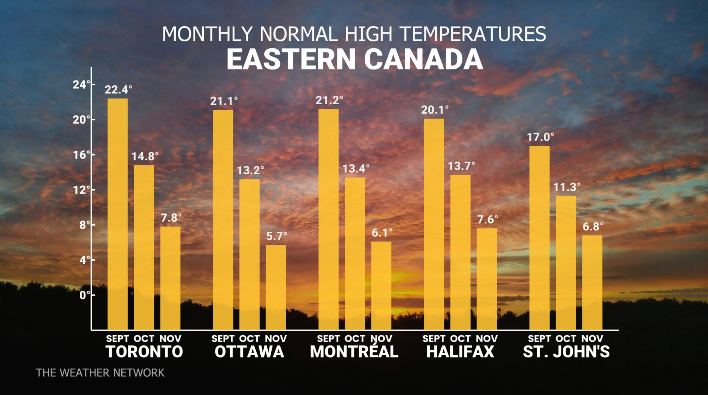
Average temperature highs for the fall season across parts of Eastern Canada. (The Weather Network)
SEE ALSO: Three reasons why you could see an early-fall snow in Canada
However, the mild pattern is expected to break down before we reach the end of the season. While the timing is still uncertain, we could see an abrupt pattern change to a colder and more stormy pattern as we approach early winter.
Whenever colder weather does arrive, the Great Lakes will be warmer than normal at the time, helping to set the stage for substantial lake effect events, especially for ski country.
WATCH: Ontario's 2024 Fall Forecast
Quebec
Warmer than normal temperatures are expected to dominate through October. While we have already had a couple shots of autumnal weather, mid- and late-September will feature summer’s grand finale for Montreal and Quebec City with an extended period of warm and mostly dry weather. Warmer than normal temperatures are expected to dominate during most of October, with periods of pleasant weather for enjoying the fall colours.
Fewer than normal fall storms are expected through October, but we have a heightened risk for a couple of potent storms, which could pack quite a punch as shots of cooler weather interrupt our mild spells. We will also be closely watching the tropics and the potential for impacts from the remnants of tropical storms or hurricanes.
However, the mild fall pattern is expected to break down before we reach the end of the season. While the timing is still uncertain, we could see an abrupt pattern change to a colder and more stormy pattern as we approach early winter.
WATCH: Quebec's 2024 Fall Forecast
Nova Scotia, New Brunswick and P.E.I.
Changeable temperature patterns are expected to continue through the fall. While there will be alternating periods of warmer than normal and cooler than normal temperatures, we expect that above-normal temperatures will win out for the season, especially through October.
Precipitation totals are expected to be near normal across much of the region, but southern areas, including Halifax and Charlottetown, have the potential to be wetter than normal due to the risk of excessive rain events from the remnants of tropical storms and hurricanes.
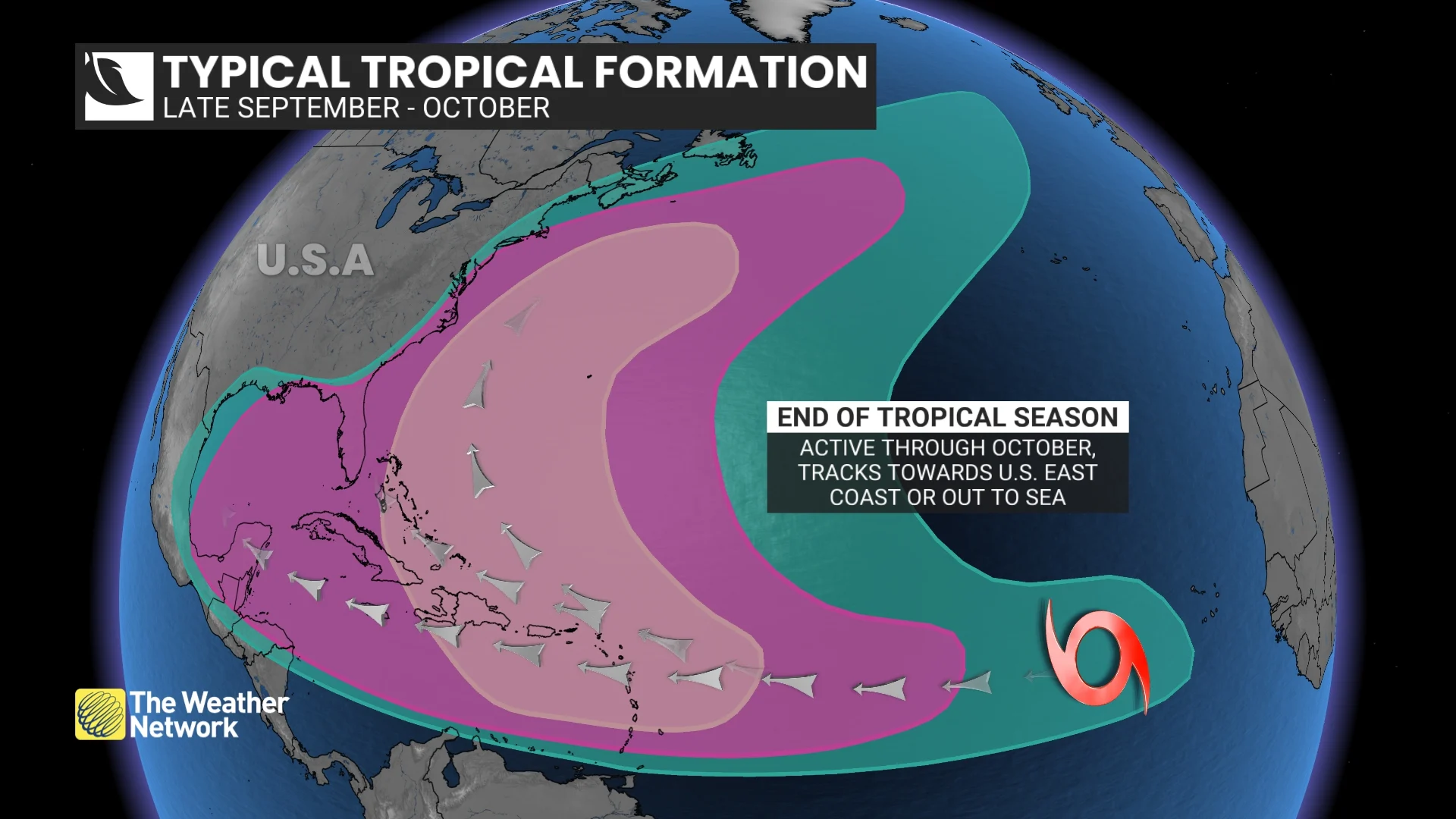
While the hurricane season turned rather quiet for a while, the tropics have come back to life. We expect that the second half of the season will be much more active with a weather pattern that is conducive for tropical systems to have an impact on the region.
Aside from the risk for tropical systems, we expect fewer than normal traditional fall storms through October. However, the pattern should become more active during November.
WATCH: After a slowdown, will hurricane season be ramping up again?
Newfoundland & Labrador
A warmer than normal fall season is expected overall, but we will continue to see changeable temperatures with occasional periods of colder than normal weather that interrupt the stretches of mild weather.
Precipitation totals are expected to be near normal across much of the province, but southern areas, including St. John’s, have the potential to be wetter than normal due to the risk of heavy rain events from the remnants of tropical storms and hurricanes. While the hurricane season turned rather quiet for a while, the tropics have come back to life. We expect that the second half of the season will be much more active with a weather pattern that is conducive for tropical systems to have an impact on parts of the province.
Aside from the risk for tropical systems, we expect fewer than normal traditional fall storms through October. However, the pattern will become more active during November.
WATCH: Atlantic Canada's 2024 Fall Forecast
Northern Canada
Warmer than normal temperatures are expected to dominate across most of the region, but near-normal temperatures are expected across the Yukon, including Whitehorse, and into western parts of the Northwest Territories (N.W.T.). Near-normal or above-normal precipitation is expected across the region. Above-normal totals are most likely across much of the N.W.T., including Yellowknife, and into western Nunavut.