A fickle fall: Strengthening El Niño triggers a two-faced season
Will it be a more traditional fall season across Canada, or is winter-like weather lurking just around the corner? Here's what to expect over the next three months.
September has featured record heat, wildfires, frost, and major threats from the tropics. Is this tumultuous weather an indication of what we can expect over the next few months as we transition from summer to winter? Read on to find out.
Changeable weather is the trademark of the fall season, but our fall forecast for the rest of September, October, and November highlights our expectation that this fall will be especially fickle.
One of the keys to this forecast are the strong El Niño conditions, which are expected to continue to develop through the fall season.
Not only is the atmosphere going through a major transition as we progress from summer to winter, but ocean water temperatures in the tropical Pacific (which are a key driver of global weather patterns) are also completing a major reversal after three years of strong La Niña conditions.
As a result of this pattern, most Canadians will enjoy a period of mild and quiet weather before an extended stretch of colder-than-normal weather arrives during the heart of the fall season.
RELATED: The science behind the Equinox
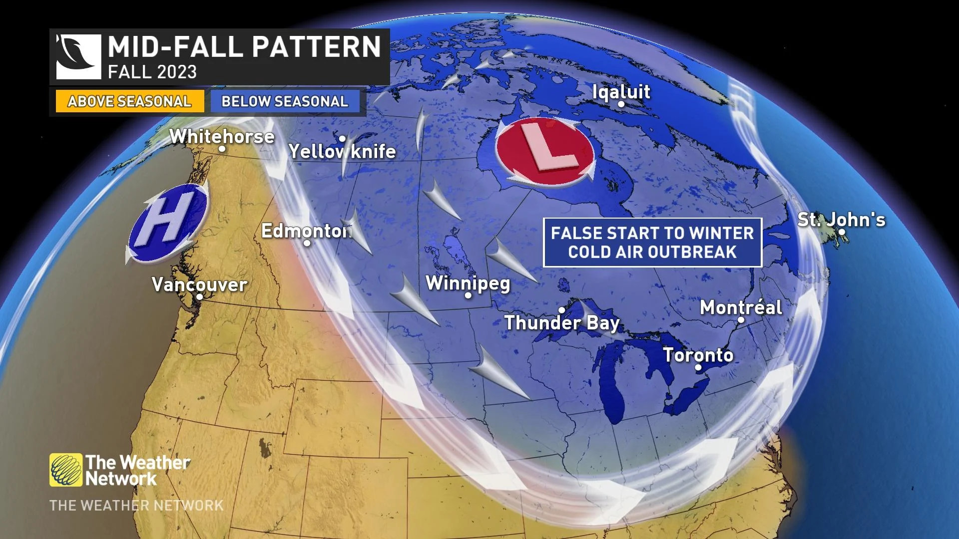
When the cold air eventually arrives, it could give Canadians the impression that winter is in a hurry to get started. However, any early winter-like weather during the fall season will be a false start to winter, not the actual start of winter. We expect that warmer-than-normal temperatures will return during November and continue well into December.
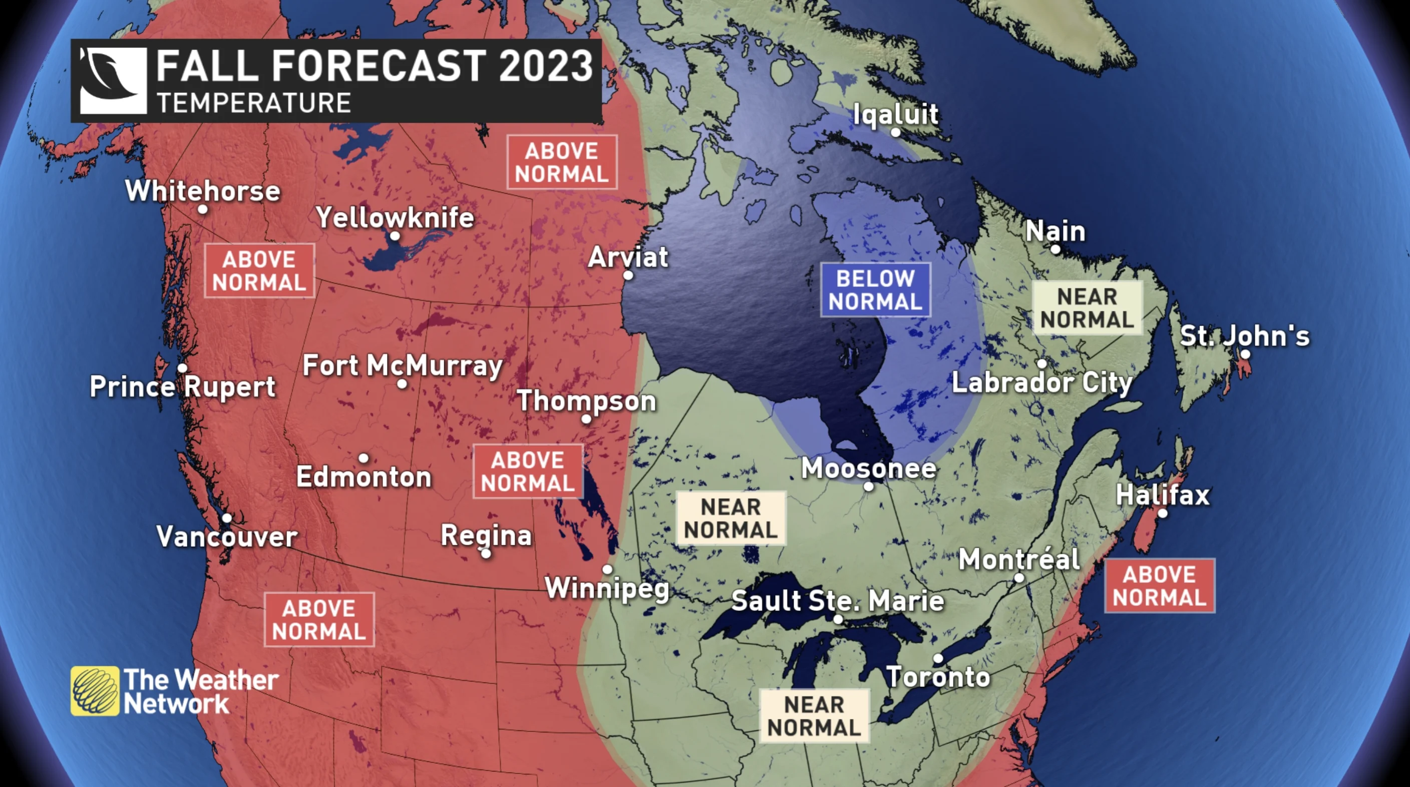
So, when we step back and look at the big picture, we expect that nearly all of Canada will see above-normal or near-normal temperatures for the fall season as a whole. The periods of colder-than-normal weather and early shots of wintry weather will be offset by extended periods of mild weather.
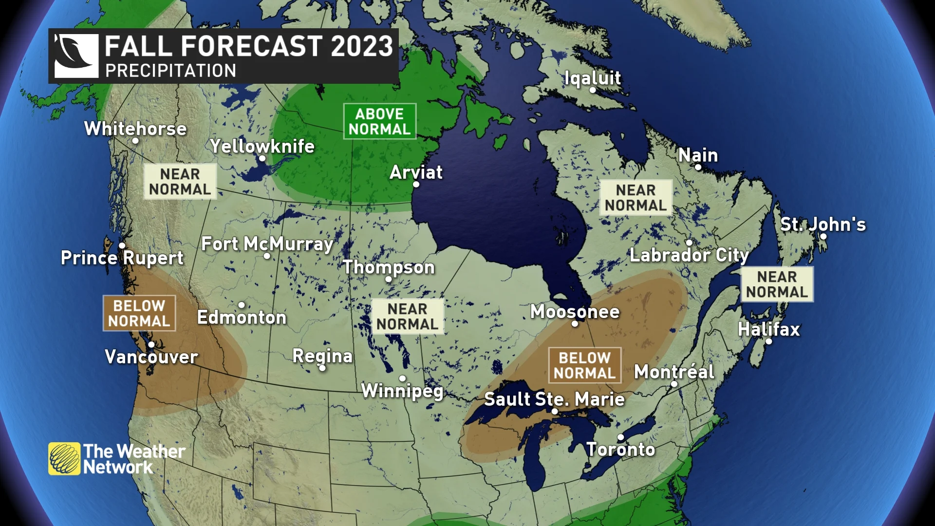
Typically, October and November feature classic fall storms. This year, we expect that Canada will see fewer storms than what we usually see during a typical fall season. However, a couple of the storms that do occur will have the potential to be memorable, with a risk of excessive rain and high winds for many Canadians.
RELATED: The science behind Canada's 'classic' fall storms
Below is a more detailed look at the regional conditions that we expect across Canada this fall.
British Columbia
Once again are dealing with wildfires and smoke later than normal into the fall season. However, significant relief from the dry conditions is at our doorstep as the final week of September will finally bring a wet pattern to the south coast region. Rain totals across the interior will not be sufficient to extinguish the fires, but are finally turning the corner on what has been an extremely long and historic fire season.
However, the wet pattern during the final week of September is not a sign of what is to come for the rest of the season. We expect that a mild and dry pattern will return and be the dominant pattern for the fall season.
Despite the forecast for drier conditions overall, we are concerned about the risk of a couple of high-impact storms before the end of the season. The widespread warmer-than-normal ocean water temperatures in the north Pacific supports a risk for excessive rain with any strong storms that impact the region.
An obvious concern with a fall season that is warmer and drier than normal is the potential for a late start to the ski season. However, it is much too early to panic about the start of the ski season. If we were to see a well-timed and moisture-laden storm during mid-to-late November, that would go a long way towards getting the season off to a solid start. We will take a closer look at that potential when we release our November forecast on November 1st.
British Columbia's 2023 Fall Forecast: What an El Niño pattern means for fall storms
Alberta
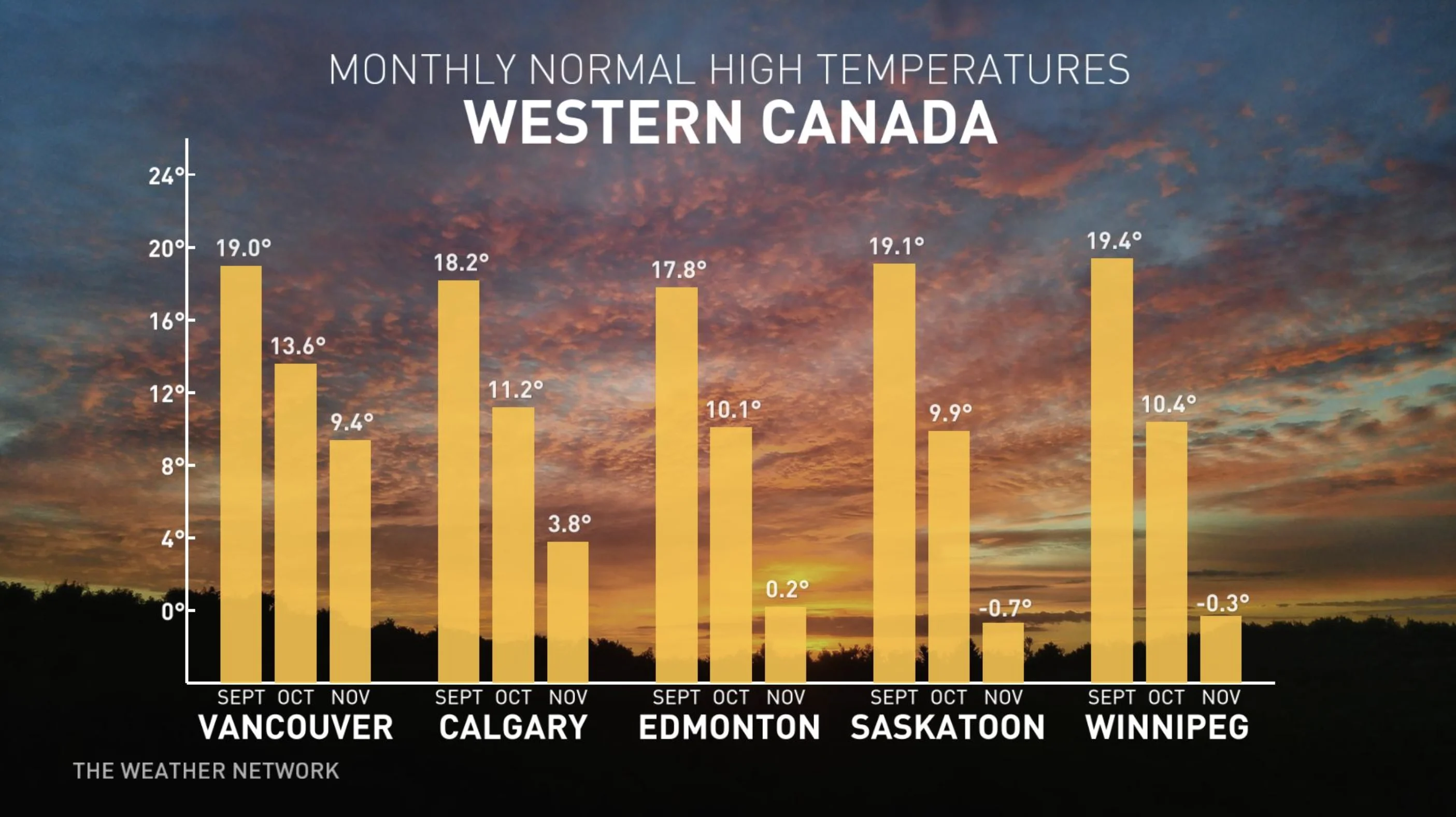
Warmer-than-normal temperatures are expected to dominate much of the upcoming season. However, like every other fall season, this fall will include shots of early winter-like weather and possibly even a more extended stretch of cold temperatures before warmer than normal weather returns for the end of fall and into the beginning of winter.
Drier than normal conditions are expected across southern parts of Alberta (including Calgary), but near-normal precipitation is expected elsewhere (including Edmonton).
Saskatchewan and Manitoba
Overall, a mild fall is expected across the two provinces, along with near-normal precipitation totals. However, we are watching the potential for a stretch of colder than normal temperatures, especially across eastern parts of the region during the heart of the season. This could include a few shots of significant early winter-like weather.
However, while winter will taunt us at times, we expect temperatures to return during November and continue to dominate through most of December.
Prairies 2023 Fall Forecast: A cold air outbreak could interrupt the season
Ontario
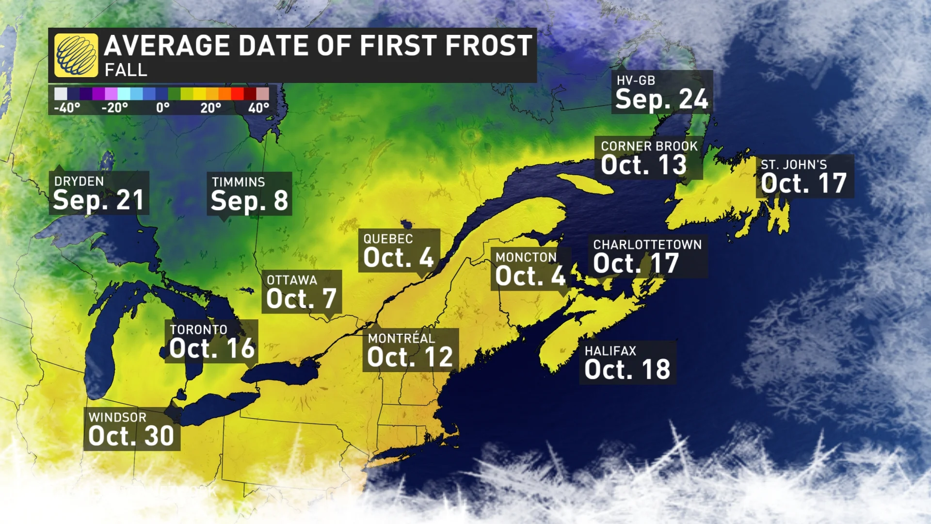
After enjoying extended periods of warm and dry weather during September and into early October, we expect a more abrupt transition to periods of colder-than-normal weather during October. We could even get the impression that winter is plotting an early arrival this year with an early freeze and lake effect snow in the snowbelt region.
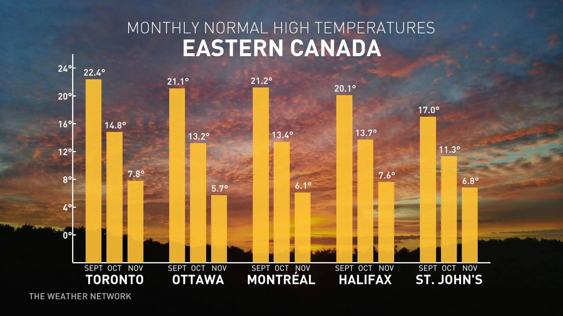
However, the weather is expected to take another turn in November, when we expect a rather mild weather pattern to return and continue through much of December. The alternating periods of warm and cold weather should come close to offsetting each other and result in near-normal temperatures for the season as a whole.
As for precipitation, fall storms are a regular part of October and November in Ontario, and this year has the potential for a couple of high-impact storms. However, despite the risk of a memorable storm, we expect that the total number of storms will be less than what we see during a typical fall season.
For those looking forward to hitting the slopes, unfortunately, the mild start to winter could also mean a delayed start to the ski season.
Ontario's 2023 Fall Forecast: Will a big temperature drop usher in an early winter?
Quebec
Late September and early October will continue to be warmer and drier than normal, but we expect a more abrupt transition to periods of colder-than-normal weather later in October. We could even get the impression that winter is plotting an early arrival this year with shots of early winter-like weather. However, rather mild weather is expected to return during November and continue through December.
Near-normal temperatures are expected for the season, as the alternating periods of warm and cold weather should come close to offsetting each other. However, a milder start to winter could mean a delay in the start of the ski season.
October and November typically bring classic fall storms to the region, and this year has the potential to deliver a couple of high-impact storms. However, despite the threat of a significant storm, we expect that the total number of storms will be less than what we see during a typical fall season.
Quebec's 2023 Fall Forecast: Will shots of winter end fall early?
Nova Scotia, New Brunswick, and P.E.I.
After a warm start to the season during September, we expect that we will settle into a more typical fall pattern with alternating periods of warmer than normal and colder than normal temperatures. This should result in near-normal or slightly warmer-than-normal temperatures for P.E.I. and New Brunswick, with temperatures tipping toward the warm side of normal across Nova Scotia.
We will continue to keep a close eye on the tropics through October, with a heightened risk for another excessive rain event. However, aside from our concerns about storms with tropical connections, we expect fewer-than-normal typical fall storms throughout the season. This should result in most of the Maritimes seeing near-normal precipitation and the potential for parts of the region to be drier than normal.
Atlantic Canada's 2023 Fall Forecast: Cooler temperatures make an early appearance
Newfoundland and Labrador
After a mild September, we forecast that Newfoundland and Labrador will transition into a more typical and changeable fall pattern. The back-and-forth temperature swings should come close to offsetting each other (or tip slightly to the warm side of normal), but southeastern parts of the province, including St. John’s, should end up warmer than normal for the season.
We will continue to keep a close eye on the tropics and the threat of remnants of a tropical system impacting the region. However, aside from our concerns about storms with tropical connections, we forecast fewer 'regular' storms than normal for the season. This should result in most of the region seeing near-normal or below-normal precipitation across parts of the region.
Northern Canada
Warmer-than-normal temperatures are expected to dominate across western and central parts of the region, including Yellowknife and Whitehorse, with near-normal to slightly colder-than-normal temperatures across eastern parts of the region, including Iqaluit.
As for rain and snow totals, our forecast is for near-normal or above-normal precipitation across the region, which will finally bring an end to another difficult wildfire season.
Late Fall and Early Winter
As we look ahead to the second half of November and into December, preliminary indications are that much of Canada will see above-normal temperatures. As we look back in history at years that had a similar global pattern to what we anticipate over the next few months (including a developing strong El Niño), we see that typically mild Pacific air tends to dominate across most of Canada, with consistent frigid weather locked up across far northern areas.
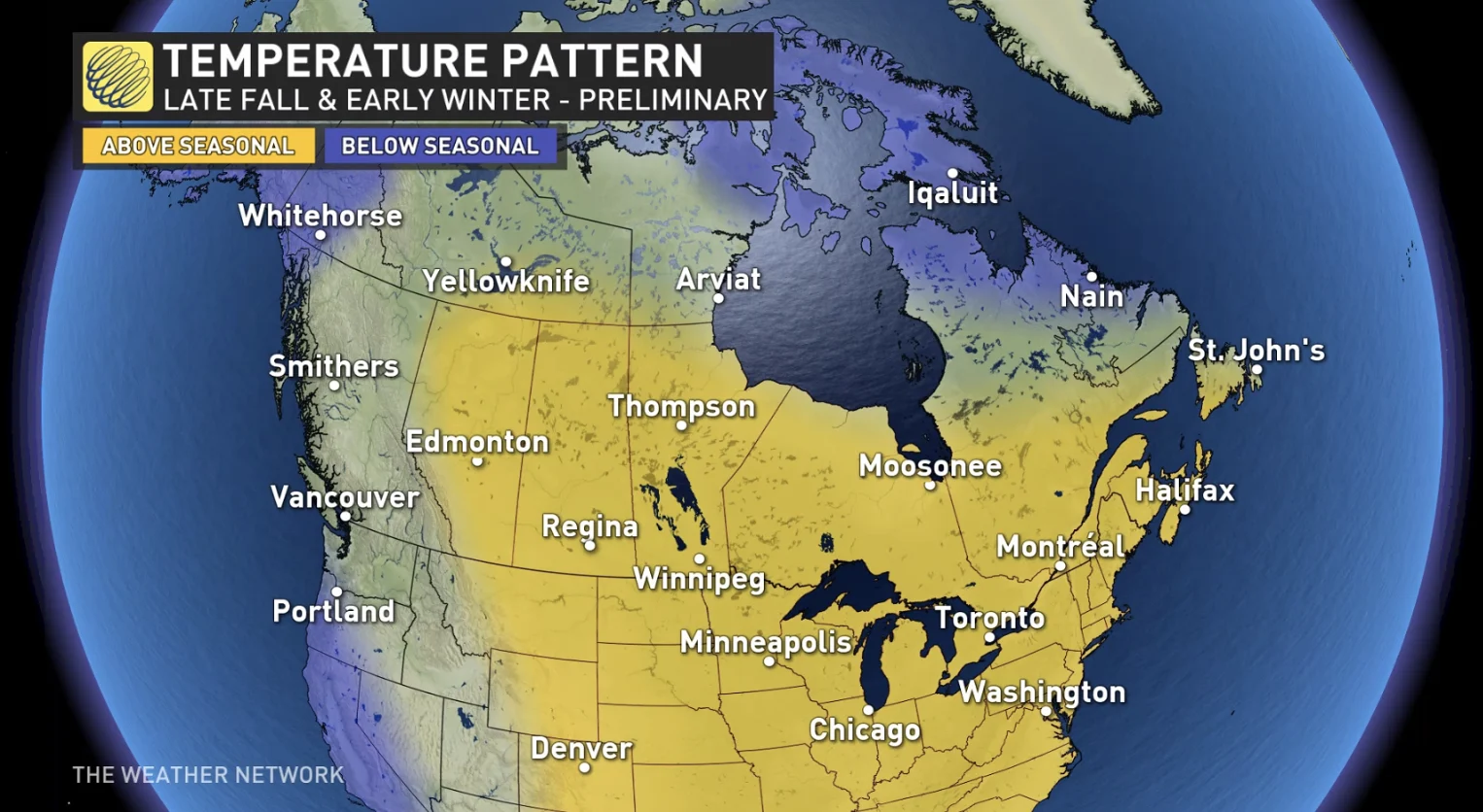
While this pattern could certainly break down at times, we expect that much of Canada will see a significant delay in the arrival of consistent winter weather.
Will this pattern continue deep into the winter season? Check back on November 29th to find out with the release of our official 2023-24 winter forecast!


