Snowy surprises can blanket Canada during a typical November
Welcome to the beginning of routine winter weather across Canada
Thanksgiving and Halloween are behind us and we're looking forward to the start of the holiday season. That can only mean one thing: snow!
November marks the beginning of routine winter weather across Canada. Just about everyone can expect to see a little bit of accumulation through a typical month.
But who averages the most snow every November, and where can we see wintry surprises?
DON'T MISS: Why the Great Lakes produce some of the world’s heaviest snow

Bursts of snow that started in October are a common sight throughout Canada during the month of November.
Cold air shoving south out of the Arctic eventually overpowers the pushes of warm air attempting to stream north of the border, allowing frozen precipitation to take hold and begin to dominate.
Just about every major city across Canada averages at least a little bit of snow in a typical November.
DON'T MISS: Canada's 2024-25 ski season is almost here! When do resorts open?
The most reliable snows fall across B.C.’s mountains, the Rockies, interior sections of Quebec, and across Northern Canada. Folks in places like Yellowknife typically see several dozen centimetres of snow during a typical November.

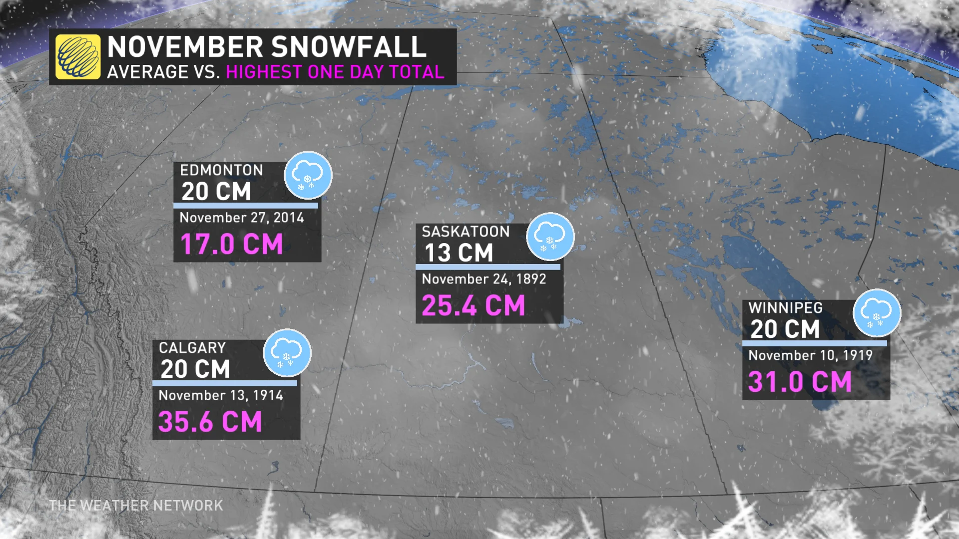
Bursts of snow will more frequently creep onto the Prairies, where Calgary, Edmonton, and Winnipeg all average about 20 cm of accumulation each November. Bigger storms can happen, though. Calgary and Saskatoon have racked up 20+ cm of snow in a single day in past Novembers.
MUST SEE: What does a classic fall storm look like in your part of Canada?
Things are a little trickier across Ontario where we have to contend with the Great Lakes. Cold air blowing over the warm waters is a recipe for lake-effect snow. These bands of heavy snow can produce blizzard-like conditions.

But conditions can vary greatly across southern Ontario, and even throughout the Greater Toronto Area, as bands whip off the lakes with snowfall rates so intense that thunder and lightning are sometimes possible.
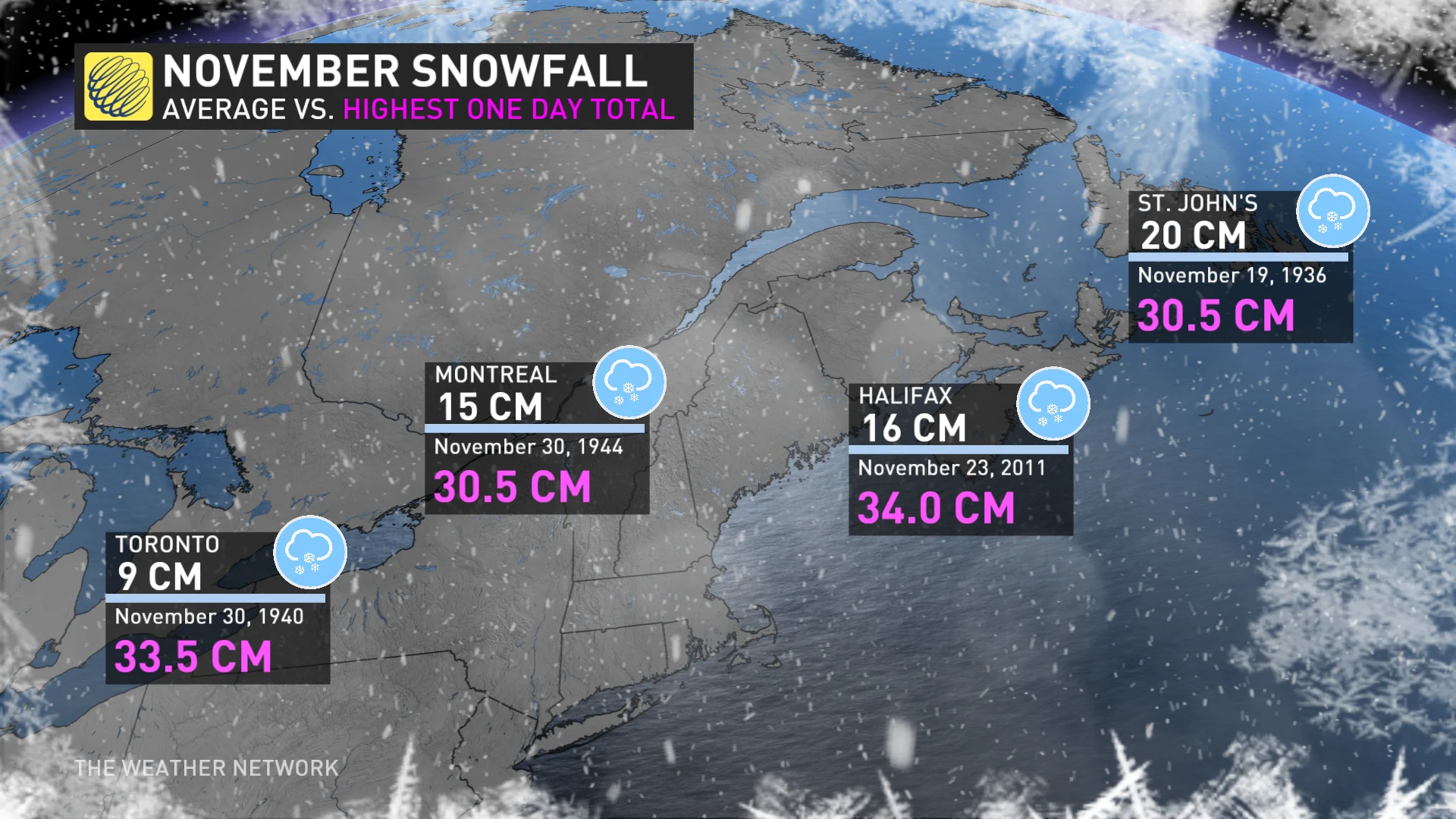
Toronto averages about 9 cm of snow every November. We’ve seen much more than that in some seasons. November 1940 brought the city a whopping total of 61 cm of snow.
Communities in the snow belts—downwind from Lake Huron, Georgian Bay, Lake Erie, and Lake Ontario—can see much more snow as the lake-effect season kicks up in November. Some of the storms can be a doozy. One particularly wicked lake-effect snow event back in the middle of November 2014 produced 165 cm of snow near Buffalo, New York.

Looking east and away from the lakes, the nation’s capital and southern Quebec typically see a few good dustings of snow during an average November. Ottawa averages about 19 cm of snow this month, while Montreal comes in with a touch less at about 15 cm.
Eastern Canada can find itself in the path of some wintry surprises of their own. Nor’easters roaring up the eastern seaboard can bring hefty snows to cities like Halifax and St. John’s, where we’ve seen 30+ cm of snow fall in a single November day as recently as 2011.
WATCH: The lake-effect snow machine, how and why it happens
Header image courtesy of Unsplash.


