All-time records shattered as Canada’s weather turns upside down
An astonishing bevy of rainfall and heat records fell this week as a strange pattern enveloped Canada
Montreal just trudged through its wettest day on record. Communities in the Northwest Territories logged Canada’s hottest temperatures several times this week.
It’s hard to shatter all-time records any day, but to see multiple records fall within the course of a few days takes some serious effort aloft.
The country’s weather turned upside down this week as strange patterns evolved from coast to coast. Here’s a look at some of the astounding records that have fallen over the past couple of days, and what it could mean for your conditions heading into next week.
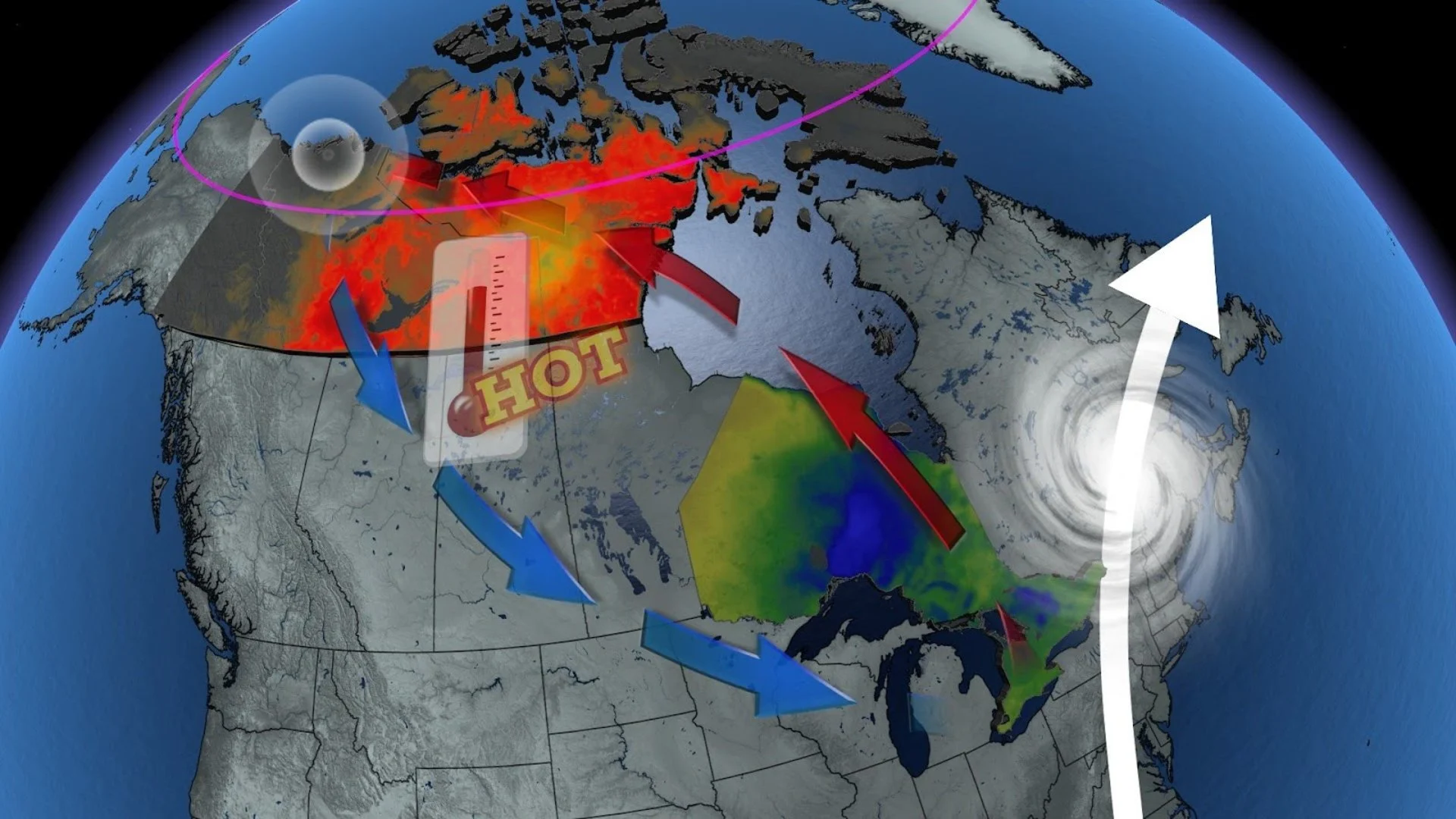
A weak Rex block leads to topsy-turvy conditions
Blocking patterns high in the atmosphere act like traffic jams that lock conditions in place for days on end.
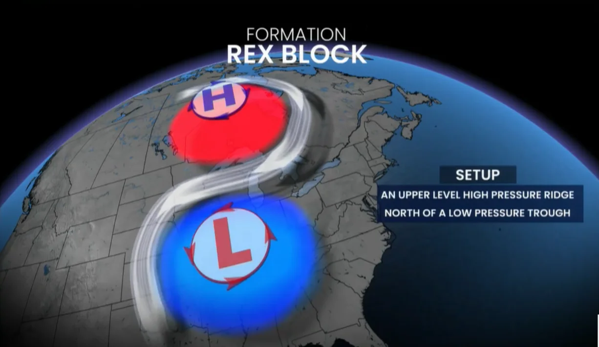
We witnessed one such pattern this week as a weak Rex block developed over the country. Rex blocks occur when a centre of high pressure gets trapped north of a centre of low pressure, resembling a backwards letter ‘S’ on weather maps.
This blocking pattern acts like a kink in a garden hose that dams up the atmosphere and prevents the pattern from continuing on its merry way like we’d see during normal conditions.
Record heat bathes the Arctic Circle
That ridge over the Far North led to some historic heat for four consecutive days this week.
Temperatures soared into the mid-30s deep into the Arctic Circle, where highs at or above 35°C were a common sight across the Mackenzie River basin and along the shores of the Arctic Ocean.
A high temperature of 37.0°C in Fort Good Hope was the warmest temperature ever recorded during the month of August in the Northwest Territories.

Little Chicago, N.W.T., hit 36°C several times. This was not only their hottest temperature ever recorded there, but these lofty highs made the site hotter than both Miami and Los Angeles. The community of Inuvik also recorded its hottest-ever temperature when the reading there soared to 34.8°C—nearly double the seasonal high for the first half of August.
The heat finally began to ease heading into this weekend, but readings will remain in the lower 30s through Monday. What’s even more astonishing is that these readings are 10 degrees warmer than what we’ll see across the southernmost part of the country.
An upper-level trough beneath that heat ridge to the north sent cooler and less humid air diving south for the weekend, bringing comfortable below-seasonal temperatures into Ontario even as folks in the Arctic Circle deal with record-breaking heat.
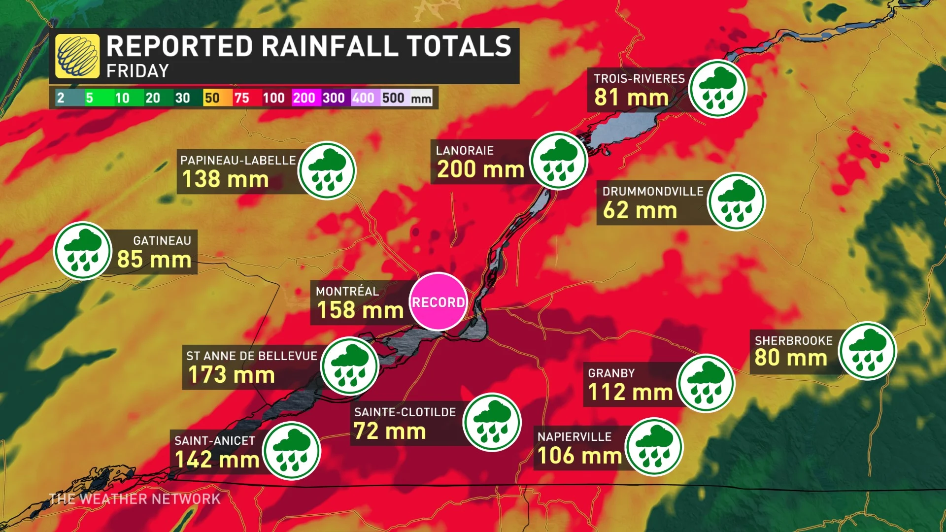
Tropical remnants shatter Montreal’s rainfall record
It’s not just temperatures across Canada that are turned on their head. The remnants of Hurricane Debby brought torrential downpours to Eastern Canada to end the week—but the system itself hit the region in an unusual manner.
When you’re tracking the remnants of tropical systems in Atlantic Canada, the worst impacts are almost always found along the coasts of Nova Scotia and Newfoundland. That wasn’t the case with Debby.
RELATED: Southern Quebec still struggles with remnants of tropical storm Debby
The same upper-level low over Ontario that’s bringing cooler conditions to the province also influenced Debby’s track. As a result, the system stayed unusually far to the west, bringing the worst impacts to eastern Ontario, Quebec, and interior sections of New Brunswick instead.
Montreal saw a whopping 158 mm of rain from Debby’s remnants on Friday, making August 9, 2024, the new benchmark for the highest one-day rainfall total recorded at Montreal Airport. The previous all-time one-day rainfall record was 87.6 mm set back in 1880. This led to significant flooding across the province.
Communities throughout the province saw rainfall totals well in excess of 100 mm, with some areas closing in on 200 mm by the time precipitation finally cleared out of the region early Saturday.