Ontario’s incoming heat ridge helped fuel New York’s historic floods
Record rains fell on New York City to close out the month of September, triggering widespread and destructive flooding throughout the city’s boroughs
Torrential rains sent a deluge of water careening through the streets of New York City to end the final week of September, dropping more than 200 mm of rain in mere hours in one of the most intense rainstorms ever recorded in parts of the city.
The downpours that flooded the largest city in the United States had a Canadian connection. It’s a grim example of how the atmosphere is interconnected, and how one extreme begets another in the atmosphere’s everlasting efforts to keep things balanced.
Visit our Complete Guide to Fall 2023 for an in-depth look at the Fall Forecast, tips to plan for it and much more!
Any flooding tends to have significant consequences in a densely populated area that’s home to more than eight million people, but the focused nature of the downpours brought widespread and severe flooding across much of New York’s boroughs.
Rain began falling late Thursday night, picking up Friday morning with ferocious intensity. Extreme rainfall rates quickly overwhelmed the city’s labyrinthine network of storm sewers, allowing runoff to fill the streets with water deep enough to send cars floating.
RELATED: Streets turn into small lakes in New York as heavy rain triggers flooding
Cascades of water gushed into the network of subways, leaving commuters fleeing as rivers of water fell from the ceilings and some stations harboured a slurry of toxic, waist-deep floodwaters.

All told, John F. Kennedy International Airport recorded nearly 220 mm of rain, much of which fell in a single day to break the location’s all-time wettest day since records began back in the late 1940s.
WATCH: NYC streets under water after a month's worth of rain falls Friday
Much of the rain fell in a narrow stripe centred right over New York City, with totals of 140-180+ mm reported across Manhattan, Brooklyn, Queens, and the Bronx. A sharp cutoff brought lower totals to both the city’s east and the west.
These downpours trained over New York City, meaning that they redeveloped and moved over the same areas for hours at a time, much like train cars on railroad tracks.

These downpours formed as part of the same pattern change that’ll bring record warmth to Ontario heading into the first week of October.
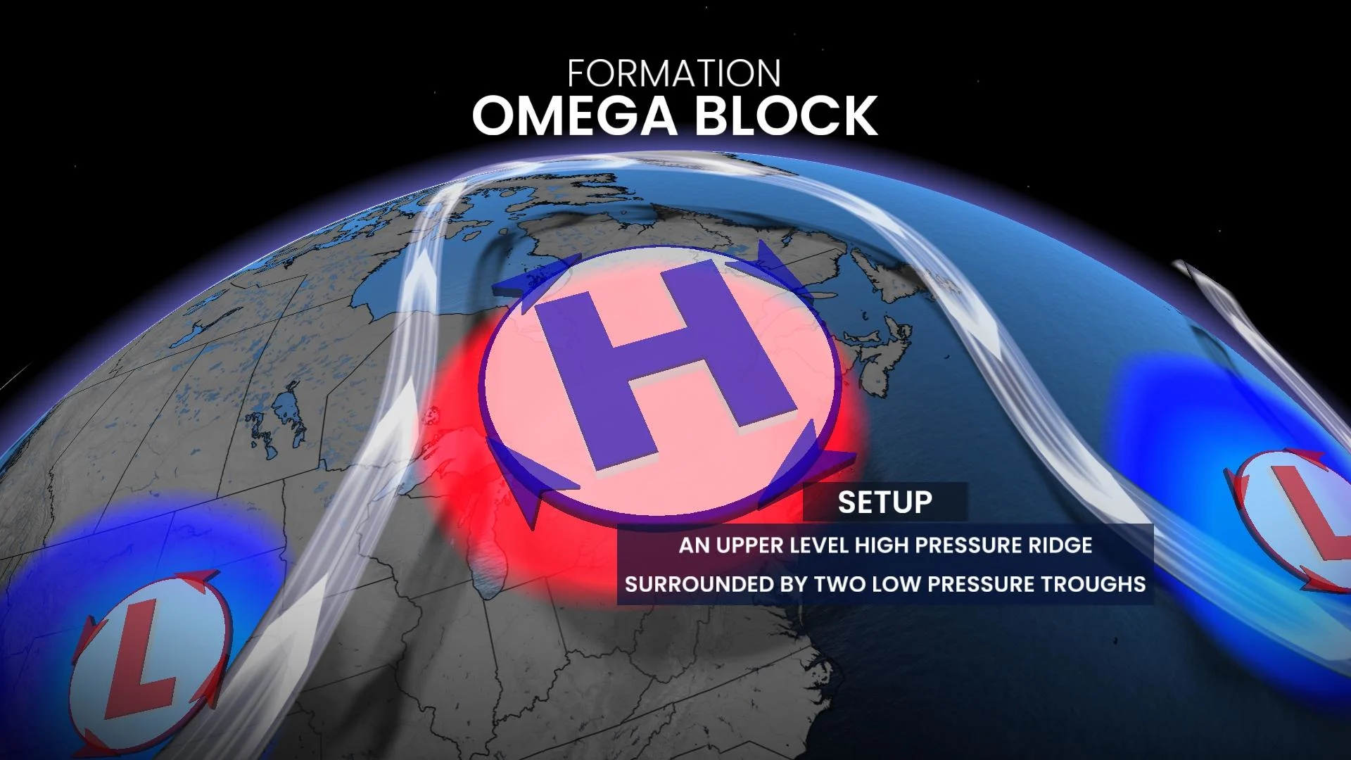
A large ridge setting up over the Great Lakes will get ‘trapped’ in place by troughs on either side. This Omega block, as it’s known, tends to bring warmth to those under the ridge and unsettled conditions to those stuck beneath the troughs.
SEE ALSO: Trapped in your car in floodwaters? This tool can help you make a quick escape
One of the troughs involved in this complex pattern swept over the U.S. Northeast on Thursday and Friday, enhancing the lift needed to fuel repeated rounds of thunderstorms over New York City.
The storms had an assist from the remnants of Tropical Storm Ophelia, which have lingered over the western Atlantic for the past week. Ample tropical moisture associated with those remnants gave the downpours the added boost needed to feed record rain totals.
Header image courtesy of Juliana Fonda via Storyful.


