Water breaches landslide damming Chilcotin River in B.C.
People are being urged to stay away from the banks of the Chilcotin and Fraser rivers after water finally breached the dam created by last week's huge landslide.
The province of British Columbia issued an emergency alert Monday morning after water began spilling over the slide blocking the Chilcotin River.
SEE ALSO: 2 new wildfires of note in southern B.C. as hot, dry spell begins
The alert, sent at at 10:35 a.m. PT, urged residents anywhere along the banks of the Chilcotin River from Hanceville to the Fraser River, and anywhere along the banks of the Fraser River from the Chilcotin River to the Gang Ranch bridge around 25 kilometres downstream, to evacuate immediately.
At a news conference Monday afternoon, Connie Chapman with B.C.'s Ministry of Water, Land and Resource Stewardship said the water had since created a 15-metre-wide channel in the dam and was breaching it at a "moderate pace." She added the dam is carrying wood debris downstream.
Gerald Pinchbeck with the Cariboo Regional District Emergency Operations Centre told CBC News earlier that it's the debris he's worried about.

"The going concern are debris flows, which aren't included in the [river flow] modelling. We don't know what those impacts will be, but our concern is for the safety of people and infrastructure in the area," said Pinchbeck, who added that water had begun moving over the dam around 9 a.m. PT.
As more water moves over the slide, officials are expecting it to carry more debris, including fallen trees. Water levels along the Chilcotin River are expected to rise far above normal spring melt levels, while water levels along the Fraser River are expected to be below spring levels.
"I cannot underline enough how extremely dangerous the valley is right now," Emergency Preparedness and Climate Change Minister Bowinn Ma told reporters at the 2 p.m. briefing.
"We need people to stay off the Chilcotin and Fraser rivers and stay away from the river banks."
She said it's not clear when the rivers and their banks will be safe again.
Evacuation orders, alerts
Evacuation orders are in place along parts of the Chilcotin and Fraser rivers, affecting about 11 properties and about 10 people in the Cariboo Regional District.
On Sunday night, the Cariboo Regional District issued three new evacuation orders along the Fraser River. One covers about 9.6 square kilometres along the Fraser River, just south of where it meets the Chilcotin River. A second order covers 3.5 square kilometres along the Fraser River just north of that confluence, upstream.

The Tŝilhqot'in National Government is asking people to stay away from the Chilcotin River due to unpredictable water behaviour following a landslide. (Deb Ilnicki/Facebook)
"Once the water hits the Fraser River from the Chilcotin River, it'll go where it can," Pinchbeck said. "If there's enough water coming down, it will go upstream and also it will eventually flow downstream."
A third evacuation order covers 1.5 square kilometres along the Fraser River, about 25 kilometres south of where the two rivers meet. It includes the Gang Ranch Suspension Bridge.
Evacuation orders also remain in place for about 100 square kilometres of land along the Chilcotin River, both upstream and downstream from where the landslide happened near Farwell Canyon.
In total, evacuation orders stretch from near Hanceville, B.C., to where the Chilcotin and Fraser rivers meet.
On Monday afternoon the B.C. River Forecast Centre also issued a flood warning for the Fraser River from the Chilcotin River confluence to Big Bar.
Several jurisdictions also issued evacuation alerts, which ask residents to prepare for an evacuation at short notice.
Just after noon on Monday, the Thompson-Nicola Regional District issued an evacuation alert for all private properties within 300 metres of either side of the Fraser River, including four properties it listed in the Big Bar area.
The regional district posted a map of the evacuation alert area online.
The Cariboo Regional District has an online interactive map showing an evacuation alert along either side of the Fraser River within its jurisdiction.
Peak flows
In a news release Sunday, officials said peak flows along the Chilcotin River could be more than 10 times greater than typical levels after the spring melt.
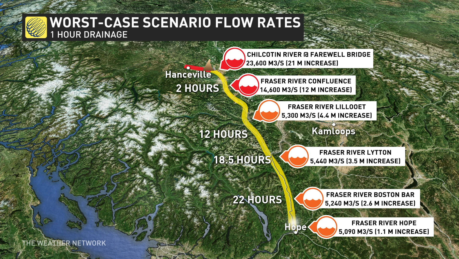
It estimates the river could rise by 21 metres at the Farwell Canyon bridge, close to the site of the landslide, about 285 kilometres north of Vancouver. Peak flow could take up to 13 hours to reach Lillooet.
Minister of Water, Land and Resource Stewardship Nathan Cullen posted video to social media of water moving past the landslide.
Cullen told CBC's On The Coast on Monday that the breach is expected to move up to three million dump trucks worth of soil in the coming days.
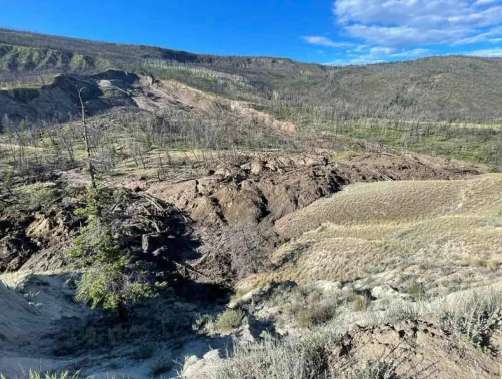
The landslide was first reported by residents near Farwell Canyon last Wednesday morning. The slide created a dam about 30 metres high, 600 metres wide and a kilometre long.
Since then, officials have warned that water would eventually spill over the dam.
Chapman told reporters Monday that risks to public safety include the potential for further landslides upstream of the natural dam and downstream of the dam once water begins to flow past it.
On Sunday the province launched a new Chilcotin River landslide information portal to share the latest information about the slide with the public.
Chapman said staff that were previously studying the landslide have been moved a safe distance away, where they continue to assess the area.
They expect an increased risk of landslides about 16 kilometres upstream of the landslide, and have already seen some smaller ones.
According to Chapman, from the time water breached the dam until noon on Monday, the lake that had built up behind the slide was dropping at a rate of 20 centimetres per hour. Since then, the flow of the breach has increased and the lake is dropping about 1.3 metres per hour.
Thumbnail image credit to the Cariboo Regional District via CBC News.
This article was originally written by and published for CBC News on Monday, Aug. 5.


